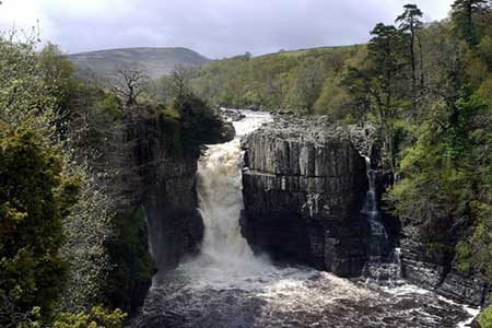
Hanging Shaw, Cronkley Scar, Low Force & High Force
North Pennines Walk
Region - North Pennines
County/Area - Durham
Author - Lou Johnson
Length - 12.7 miles / 20.6 km Ascent - 1400 feet / 424 metres
Time - 7 hours 50 minutes Grade - moderate
Maps 

| Ordnance Survey Explorer OL19 | Sheet Map | 1:25k | BUY |
| Anquet OS Explorer OL19 | Digital Map | 1:25k | BUY |
Walk Route Description
Click image to see photo description.
This walk explores Upper Teesdale in County Durham, taking through some wonderful scenery typical of the area. The small car park near Hanging Shaw (grid ref. NY867298) on the north side of the B6277 just under 6 miles north-west of Middleton-in-Teesdale provides an ideal place to start.
After parking exit the car park, turn right along the B6277 and in a few yards, go left down a driveway and continuing footpath to the bridge over the River Tees at grid ref. NY862293. Cross the bridge, turn right and follow the path to High House (grid ref. NY856294), Continue on the path beside the River Tees for two and quarter miles passing beneath Cronkley Scar and Raven Scar. The path is flanked by steep ground to your right for most of the way. However, after passing through a wall at grid ref. NY833287, you reach a more open area. Pass through another wall in 300 metres into an enclosed field. About half way along this field bear left through a gate and follow a clear rising path/track onto Cronkley Fell.
The way ahead goes to the left of a walled enclosure and then soon after to the right of a further three walled enclosures. You are now descending and shortly after the last enclosure a wall appears to your left. The route parallels this wall, passes Birk Rigg and heads off towards Holwick Scar. Soon the wall on your left turns north-east and you need to continue on the clear track in an easterly direction for just over a mile past some grouse butts to reach an indistinct path junction at grid ref. NY889275. Leave the track here and bear left and continue down to a track just beyond Hield House (grid ref. NY894279).
Bear right along this track for just over 400 metres. Turn left on the footpath leading down to Wynch Bridge (grid ref. NY903278). Do not cross the bridge, instead turn left along the Pennine Way (also part of the Pennine Journey) and continue past Low Force, over Keedholm Scar and past High Force. This is quite a long walk in its own right. From joining the Pennine Way at Wynch Bridge it is about four miles of riverside walking until you reach the bridge over Tees at grid ref. NY862293 which you crossed in the early stages of the walk. Cross the bridge and retrace your route back to the B6277. Turn right and the car park is a little way along this road on your left.
Other walks nearby
| Walk 3099 | High Force, Low Force and the River Tees | easy/mod | 7.5 miles |
| Walk 3274 | Cronkley Scar & Cauldron Snout | moderate | 8.0 miles |
| Walk 1683 | High Cup Nick & Cow Green Reservoir | moderate | 12.8 miles |
| Walk 3336 | Cauldron Snout | easy | 3.6 miles |
| Walk 3593 | Meldon Hill from Cow Green Reservoir | moderate | 9.2 miles |
| Walk 1005 | Harter Fell & Grassholme | moderate | 8.0 miles |
| Walk 1482 | Crossthwaite Common from Middleton-in-Teesdale | moderate | 9.8 miles |
| Walk 1483 | Eggleston & Romaldkirk from Middleton-in-Teesdale | easy/mod | 9.8 miles |
| Walk 1484 | Kirkcarrion from Middleton-in-Teesdale | easy | 3.5 miles |
| Walk 1485 | Hamsterley & Middleton-in-Teesdale | mod/hard | 16.5 miles |
Recommended Books & eBooks
Walking in the North Pennines
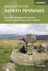 This guidebook describes 50 day walks across the North Pennines, England's remotest Area of Outstanding Natural Beauty taking in parts of Cumbria, County Durham and Northumberland. Most of the routes are circular and they range from 5 to 14 miles, with something to suit all abilities. Route descriptions are accompanied by 1:50K OS mapping.
More information
Pennine Way Map Booklet
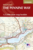 Map of the 270 miles (435km) Pennine Way National Trail, between Edale in the Peak District and Kirk Yetholm in the Scottish Borders. This booklet is included with the Cicerone guidebook to the trail, and shows the full route on Ordnance Survey 1:25,000 maps. This popular long-distance route typically takes three weeks to complete.
More information
Messaging & Social Media
Message Walking Britain and follow the latest news.

Mountain Weather
Stay safe on the mountains with detailed weather forecasts - for iOS devices or for Android devices.