Walk 3530 - printer friendly version
Roydon to Epping Walk
Author - Peter Smyly
Length - 9.3 miles / 15 km
Ascent - 400 feet / 121 metres
Grade - easy/mod
Start - OS grid reference TL405105
Lat 51.7755420 + Long 0.0350656
Postcode CM19 5EH (approx. location only)
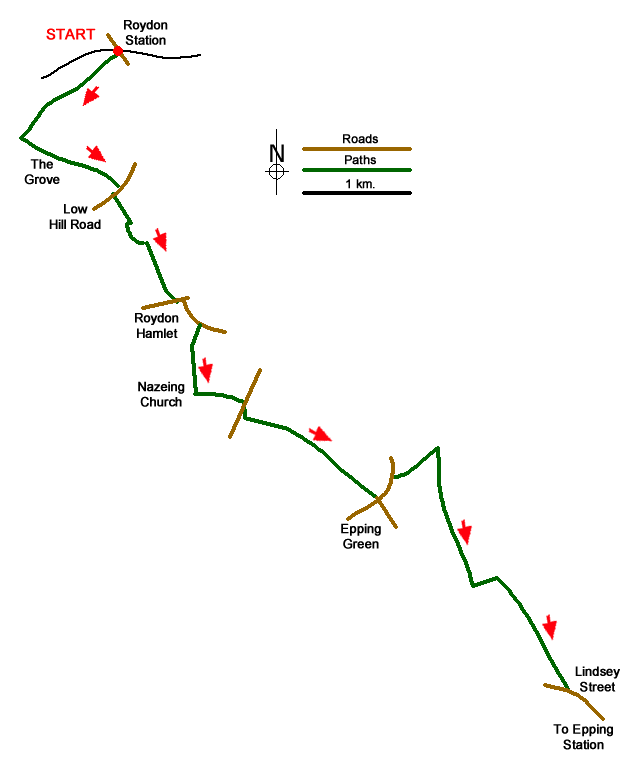
This is a linear route in rural Essex linking two railway stations. Roydon on the West Anglia Main Line and Epping at one end of the Central Line on the London Underground. Sections of the Stort Valley Way and Three Forests Way are followed. As far as possible, the route follows public footpaths, but some roadside walking is unavoidable. The three towers of Rye House power station are a distinctive landmark that is seen from different points on the route.
From Roydon station follow the canal tow path due south west as far as a point where the canal bends to the right and the waymarked Stort Valley Way leaves the canal to follow a field edge by a section of woodland (The Grove) and up a hill. Part way up the hill, the route goes sharp right through The Grove and then sharp left to emerge from it. However, if this does not appeal, especially when the approach path entering the woods is overgrown with encroaching vegetation, a much easier option is to keep going up the hill with The Grove on your right and then contouring round to the right to reach the point where the woodland path emerges into the open. Either way, follow the field ahead with a hedge on your right, keeping an eye out for a right turn through the hedge to continue the route on the other side with the hedge now on your left.
The route continues beyond Low Hill Road (after a right turn along the road) contouring around field edges and then along a narrow path where in summer, nettles may encroach, to reach a minor road. Turn right here and you are on the main road passing through Roydon Hamlet. Turn left and follow the road round to the right. This is not a very pleasant section for pedestrians and care needs to be taken with oncoming traffic. This section of this walk ends when a road leads off to the right on the opposite side to a restaurant and then a green path soon leads off this road to the left downhill from the road. At the foot of the hill, look out for a narrow path on the left and this is the way to go next, leading uphill to Nazeing Church.
Following the road ahead due south, take the next signed public footpath on the left. You leave the Stort Valley Way for now at this juncture. The route crosses a field leading to the next field. Border this field with a hedgerow on your left and, at the end of the field, continue along a narrow path to cross with care a busy main road ahead. There is nothing in the way of a pedestrian crossing, so you must wait for a break in the traffic. On the other side of the road, turn right and continue left, away from the road, along a bridleway that bends to the left and borders a cricket field on the right. Continue ahead across the next field, passing Lodge Farm on the left and then a grassy field edge path off the road to the right to reach Epping Green.
At Epping Green bear left along the pavement next to the road and continue ahead along a bridleway when the road bends left. The next bit is less easy to follow but after about 700 yards, look out for a none-too-obvious path on the right (grid ref. TL441060). If you have reached a house on the right, you have gone too far and need to turn back. Once located, the continuation route, with the houses of Epping in view on the distant horizon ahead, is waymarked across fields with occasional finger posts as far as Epping Upland. In July 2019, the way across one of the fields nearing Epping Upland was particularly overgrown - therefore a preferred alternative may be to follow the clear field edge to the right to reach the same continuation point. At Epping Upland, turn left along the road and take the next path on the right, a very wide grassy field edge leading downhill, passing through woodland briefly and then continuing across another field to reach Lindsey Street which leads into Epping and its tube station.
Messaging & Social Media
Message Walking Britain and follow the latest news.

Mountain Weather
Stay safe on the mountains with detailed weather forecasts - for iOS devices or for Android devices.