Mallyan Spout and Beck Hole from Goathland
North York Moors Walk
Nat Park - North York Moors - North York Moors East
County/Area - North Yorkshire
Author - Lou Johnson
Length - 3.0 miles / 4.9 km Ascent - 450 feet / 136 metres
Time - 2 hours 0 minutes Grade - easy
Maps 

| Ordnance Survey Explorer OL27 | Sheet Map | 1:25k | BUY |
| Anquet OS Explorer OL27 | Digital Map | 1:25k | BUY |
Walk Route Description
Click image to visit gallery of 4 images.
This short walk in the North York Moors National Park starts from the attractive village of Goathland which featured in the TV series 'Heartbeat' which was set in the 1960's. The route passes some reminders of the TV series, provides the opportunity to visit the parish church and continues down to Mallyan Spout waterfall. The onward route continues to Beck Hole from where the old railway incline is used to return to the village.
The start is the main pay and display car park in the village opposite the shops (grid ref. NZ832013). Exit the car park and turn right past the shops (on your left). You will immediately see reminders of the TV series. Continue along the pavement for about half a mile to reach the parish church (on your left) and the Mallyan Spout Hotel (on your right).
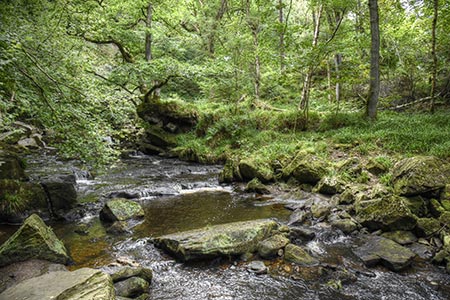
Take the signed footpath to the right of the hotel (grid ref. NZ827007). The path descends quite steeply down into a wooded valley to reach a path junction beside the West Beck (grid ref. NZ824011). Turn left here and walk beside the beck. The path ends and you have to scramble across a rocky area to reach the Mallyan Spout waterfall which is on your left. After rain the rocks may be slippery, so care is needed. However the advantage after heavy rain is that the waterfall will be very impressive!
After viewing the waterfall retrace your steps to the path junction. Go straight ahead here signed to Beck Hole. The path undulates and runs parallel with West Beck to reach a cottage at the foot of the old railway incline at Beck Hole (grid ref. NZ821020). Turn right up the well-made path that climbs up to Goathland. This incline was used to haul railway wagons from Grosmont up to Goathland before the current railway was constructed.
Continue up the clear path. Reaching a road, go straight across. The path then leads out onto another road. Keep right here and continue to the centre of the village. Turn right and the car park is on your right.
Note Alternative free parking is available on the grass verge near the Church. However, do not use the Mallyan Spout Hotel's parking.
Other walks nearby
| Walk 2563 | Egton Bridge & Grosmont from Goathland | moderate | 12.5 miles |
| Walk 1758 | Newton House Plantation & Stony Leas | moderate | 10.3 miles |
| Walk 1922 | Goathland & Howl Moors | moderate | 11.2 miles |
| Walk 1930 | Wheeldale Moor circular | moderate | 11.3 miles |
| Walk 1464 | Sleights Moor | easy/mod | 7.8 miles |
| Walk 1675 | The Esk Valley & Egton High Moor | moderate | 10.5 miles |
| Walk 1743 | Sneaton Thorpe & Littlebeck from May Beck | moderate | 8.9 miles |
| Walk 1602 | Saltergate, Fylingdales & Allerston High Moor | moderate | 11.5 miles |
| Walk 3534 | Dundale Pond & Hole of Horcum from Saltergate | easy/mod | 5.2 miles |
| Walk 2077 | Glaisdale Moor circular | moderate | 11.9 miles |
Recommended Books & eBooks
Trail and Fell Running in the Yorkshire Dales
 Guidebook to 40 of the best trail and fell runs in the Yorkshire Dales National Park. Ranging from 5 to 24 miles, the graded runs start from bases such as Ribblehead, Dent, Sedbergh, Malham and Grassington and take in the region's diverse delights, from castles and waterfalls to iconic mountains such as Whernside, Ingleborough and Pen Y Ghent.
More information
Messaging & Social Media
Message Walking Britain and follow the latest news.

Mountain Weather
Stay safe on the mountains with detailed weather forecasts - for iOS devices or for Android devices.