Whitbarrow Scar from Mill Side
Lake District Walk
Nat Park - Lake District - Lake District Lesser Fells
County/Area - Cumbria
Author - Lou Johnson
Length - 6.5 miles / 10.6 km Ascent - 1000 feet / 303 metres
Time - 4 hours 20 minutes Grade - moderate
Maps 

| Ordnance Survey Explorer OL7 | Sheet Map | 1:25k | BUY |
| Anquet OS Explorer OL7 | Digital Map | 1:25k | BUY |
| Ordnance Survey Landranger 97 | Sheet Map | 1:50k | BUY |
| Anquet OS Landranger 97 | Digital Map | 1:50k | BUY |
Walk Route Description
Click image to see photo description.
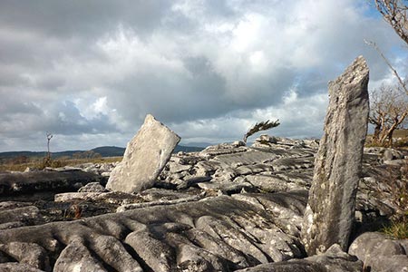
The limestone scenery of Whitbarrow Scar and the surrounding area lies a few miles west of Junction 36 of the M6 yet is overlooked by many walkers visiting the Lake District. The area has some outstanding limestone pavements and cliffs. This route needs careful navigation and a 1;25000 scale OS map is useful accessory to take on the walk. To reach the start exit the M6 and take the A590 west. At the first major interchange, continue along the A590 (signed Barrow). After just under 3 miles, turn right of the A590 and follow the road signed to Mill Side. In just over a mile you reach a road junction (grid ref. SD452839) where parking for a few cars is available.
After parking follow the road northwest to Mill Side. At Low Fell End go through the metal gate and follow the footpath through the farm. Continue on the track and continue ahead into Buckhouse Wood soon reaching a cross track (grid ref. SD452844). Turn left and at the first white arrow waymark turn right onto a permissive path leading uphill. Continue past a second white arrow heading uphill. Reaching a bench, bear sharp left following the white arrow to pass through a gap in a wall with a gate and another white arrow. Go through the gate. The path passes through a wooded area up to Farrer's Allotment. The path meanders following a route just west of north.
Reaching a wall (grid ref. SD446860) go through the gap on the left, ignoring the gate on the right. Continue ahead on the path gradually gaining height to reach a large summit cairn (grid ref. SD441871). From the cairn the path bears right heading north east to reach a path junction (grid ref. SD442874). From here follow the path with the wall on your right for about 500 metres to reach a wall junction (grid ref. SD441879). Turn left here (ignoring the ladder stile) and descend Bell Rake.
At the foot of Bell Rake (grid ref. SD435876) turn left onto a forestry track (marked as a permissive path on OS maps). You reach a junction of tracks after 350 metres where you fork left. Continue on this track for 1.3 kilometres to reach a junction just past the sports field. Turn left (grid ref. SD438861) with the sports field on your left and continue to a ladder stile (grid ref. SD440861). Enter High Crag Wood and follow the track in a generally southerly direction entering Low Crag Wood as you make progress to reach a bridleway (grid ref. SD443849). Bear left along the bridleway soon joining a road at Beck Head. Continue down the road back to the start.
Other walks nearby
| Walk 3199 | Whitbarrow Fell from Mill Side | moderate | 7.0 miles |
| Walk 1045 | Levens Bridge to Kendal | easy/mod | 11.5 miles |
| Walk 2481 | Arnside Knott Circular | easy/mod | 6.0 miles |
| Walk 2143 | Whitbarrow & Lord's Seat | easy/mod | 5.4 miles |
| Walk 1148 | Scout Scar from Sizergh | moderate | 11.0 miles |
| Walk 2721 | Scout Scar Limestone Ridge | easy/mod | 5.0 miles |
| Walk 3234 | Gummers How via Chapel House Wood, South Lake District | easy/mod | 5.5 miles |
| Walk 1417 | Astley's Plantation & Simpson's Ground | easy/mod | 7.5 miles |
| Walk 2511 | Silverdale & Arnside | easy/mod | 8.0 miles |
| Walk 3451 | Underbarrow, Lord's Lot and Crossthwaite | easy/mod | 5.6 miles |
Recommended Books & eBooks
Lake District: High Level and Fell Walks
 This guidebook describes 30 graded fell walks on the ridges and high peaks of the English Lake District, the UK's most popular national park. Reaching some of England's finest and highest mountain scenery, this guide leads readers to classic horseshoes and traditional ascents as well as lesser-known routes to quieter summits.
More information
Walking the Lake District Fells - Buttermere
 Part of the Walking the Lake District Fells series, this guidebook covers a wide range of routes to 32 Lakeland summits that can be climbed from the Buttermere, Lorton and Newlands valleys, with highlights including Haystacks, High Stile, Grasmoor and the fells of the Coledale Round. Suggestions for longer ridge routes are also included.
More information
Messaging & Social Media
Message Walking Britain and follow the latest news.

Mountain Weather
Stay safe on the mountains with detailed weather forecasts - for iOS devices or for Android devices.