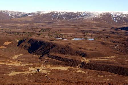
Meall a'Bhuachaille & Ryvoan Bothy from Glenmore
Cairngorms Walk
Nat Park - Cairngorms - Cairngorm North
County/Area - Highland
Author - Paul Gasson
Length - 5.5 miles / 8.9 km Ascent - 1650 feet / 500 metres
Time - 4 hours 20 minutes Grade - moderate
Maps 

| Ordnance Survey Explorer OL57 | Sheet Map | 1:25k | BUY |
| Anquet OS Explorer OL57 | Digital Map | 1:25k | BUY |
| Ordnance Survey Landranger 36 | Sheet Map | 1:50k | BUY |
| Anquet OS Landranger 36 | Digital Map | 1:50k | BUY |
Walk Route Description
Click image to visit gallery of 5 images.
This short, but spectacular, walk on good paths provides an excellent introduction to the area for the first time visitor, affording magnificent views over the Cairngorm National Park in a relatively easy half day. Though the paths are clear, good weather is desirable to make the most of the extensive views.
Park at the Forestry Commission Visitor Centre in Glenmore (GR 977098) and take the steep path just to the left of the Centre through the trees to a fork in the path. Take the left fork and climb easily, following the burn just below the track until the path emerges from the forest to open mountainside. The way ahead is badly eroded and very muddy, particularly after wet weather, and leads upwards, heading for the bealach between Creagan Gorm and our summit, Meal a'Bhuachaille. The bealach is a great spot to catch one's breath, and savour the views across Loch Morlich to the Cairngorm massif. Turn east now and climb the vague west ridge to the summit.
The way on from the summit is not clear, but bear NE across the stony summit plateau for some 200metres when a clear path appears, zig zagging steeply down, due East to Ryvoan Bothy. The descent path gives superb views into the wilderness that occupies so much of the National Park.
The one roomed Ryvoan Bothy was originally a croft dating from the 18th.century, and abandoned in 1877. It was the birthplace of a well known local character, Grigar Ruighe Bhothan, famed for both his physical strength and his capacity for the locally made strong liquor! It is said that the Creag Dhu club carried out some temporary repairs to prevent it from falling into complete disrepair until it was taken over by the Mountain Bothies Association in 1972. It is probably mostly used these days as a brief stop for casual walkers, being only an hour's walk from Glenmore Lodge , the National Sports Centre for Scotland.
A rough track now leads south west from the bothy, soon becoming much better as it passes An Lochan Uaine and continues on to Glenmore Lodge, the premier outdoor pursuits centre in Scotland. The Centre started off life as a Victorian hunting Lodge, but has now been largely rebuilt and greatly extended. During World War 2 it was used as a training base for a company of Norwegian commando's, and there is a memorial nearby to these soldiers.
From Glenmore Lodge a footpath runs parallel to the service road leading directly back to the Visitor Centre, and just before it reaches the centre, passes the Reindeer Centre, testimony to the fact that winter last longer up here than in the rest of Britain. There are refreshments and souvenirs available at the Visitor Centre, as well as picnic tables with good views across Loch Morlich.
Other walks nearby
| Walk 2412 | Craiggowrie & Creagan Gorm from Loch Morlich | mod/hard | 7.3 miles |
| Walk 1904 | Loch Morlich circular (near Aviemore) | easy | 4.0 miles |
| Walk 1605 | Loch an Eilein & Rothiemurchus Forest from Loch Morlich | easy/mod | 10.0 miles |
| Walk 2421 | Braeriach via the Chalamain Gap | hard | 15.0 miles |
| Walk 1881 | Ben Macdui & Cairn Lochan from the Ski Centre | hard | 10.4 miles |
| Walk 2672 | Cairngorm Mountain via Coire an t-Sneachda | mod/hard | 6.0 miles |
| Walk 1390 | Cairn Lochan via the Fiacaill Buttress from Ski Centre | very hard | 5.7 miles |
| Walk 1276 | Loch Avon Circular via Cairn Gorm Mountain | hard | 9.0 miles |
| Walk 2314 | Cairngorm & Ben Macdui from the ski centre | hard | 11.0 miles |
| Walk 1721 | Braeriach via Lairig Ghru | hard | 18.2 miles |
Recommended Books & eBooks
Walking in Torridon
 This guidebook contains 52 day walks in Torridon, a remote and much-loved area of the Scottish Highlands. Based around Shieldaig and Slioch, the routes are split into 3 sections: easy walks, long and high level walks and mountain ascents over 2000ft including 9 Munros, and 5 outline suggestions for major ridge walks.
More information
Great Mountain Days in Scotland
 Inspirational guidebook to 50 challenging routes for mountaineers, scramblers, hillwalkers and fell runners, many long enough to backpack over 2 days, especially in winter (12 to 25 miles). A mix of classic routes and unsung gems across Scotland from Galloway to the Outer Hebrides in widely differing wild landscapes. With customised OS mapping.
More information
Messaging & Social Media
Message Walking Britain and follow the latest news.

Mountain Weather
Stay safe on the mountains with detailed weather forecasts - for iOS devices or for Android devices.