Tadcaster and Newton Kyme
North Yorkshire Walk
County/Area - North Yorkshire - Vale of York
Author - Andy Chaplin
Length - 6.1 miles / 9.9 km Ascent - 270 feet / 82 metres
Time - 3 hours 20 minutes Grade - easy/mod
Maps 

| Ordnance Survey Explorer 289 | Sheet Map | 1:25k | BUY |
| Anquet OS Explorer 289 | Digital Map | 1:25k | BUY |
| Ordnance Survey Explorer 290 | Sheet Map | 1:25k | BUY |
| Anquet OS Explorer 290 | Digital Map | 1:25k | BUY |
| Ordnance Survey Landranger 105 | Sheet Map | 1:50k | BUY |
| Anquet OS Landranger 105 | Digital Map | 1:50k | BUY |
Walk Route Description
Click image to visit gallery of 3 images.
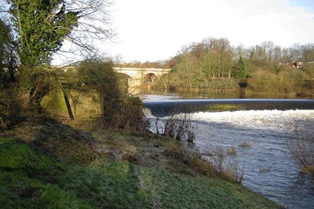
The highlights of this North Yorkshire walk are the town of Tadcaster, St Mary's Church, the walk along the River Wharfe, the railway viaduct and the church and Hall at Newton Kyme. More information about all of these structures and other points of interest along the route can be found in the TWAW leaflet on which this walk is based. For more information go to tadwalks.org.uk/Smaws/route.html. The starting point for the Walkers Are Welcome walk is from the bus station in Tadcaster whereas this route starts from the free car park in the town centre (grid ref. SE485433).
From the car park walk towards the river bridge and church then follow the path (the Ebor Way) along the west bank of the river Wharfe. After just over two miles the path turns away from the river and passes the church and Hall at Newton Kyme. From the village follow Croft Lane westwards across the A659 then take Watson's Lane to Rudgate Lane crossing over the old Church Fenton to Harrogate railway line.
Rudgate Lane heads south to Smaws Quarry where you turn left and have some good views north across the Wharfe valley. Just before the old quarry site take the footpath eastwards past Smaws Wood to the houses at Smaws Court. Follow the road south around the houses to the A659 Leeds Road.
There is a good footpath back to Station Road which heads into the centre of Tadcaster - passing en route the third Tadcaster brewery - the Tower brewery (now operated by Molson-Coors. Bear right on Westgate and Kirkgate and you will return to the car park.
Other walks nearby
| Walk 2160 | Wetherby to Follifoot without a car | easy/mod | 10.3 miles |
| Walk 1380 | Bramham Park & Newton Kyme from Kiddal Bridge | easy/mod | 10.0 miles |
| Walk 1757 | River Ouse & Moor Monkton FROM Nether Poppleton | moderate | 10.0 miles |
| Walk 1588 | Eccup Reservoir circular | easy | 4.5 miles |
| Walk 3077 | Eccup Reservoir circular | easy/mod | 7.5 miles |
| Walk 1095 | The Marton-cum-Grafton Eight | easy | 3.3 miles |
| Walk 1800 | West of Harrogate without a car | easy/mod | 9.0 miles |
| Walk 1842 | Buttercrambe & Youlthorpe from Stamford Bridge | moderate | 11.8 miles |
| Walk 1358 | Ripley & Knox circular | easy | 5.5 miles |
| Walk 2404 | Ripon Rowel Walk Leg 2 - South Stainley to Sawley | easy/mod | 8.5 miles |
Recommended Books & eBooks
Trail and Fell Running in the Yorkshire Dales
 Guidebook to 40 of the best trail and fell runs in the Yorkshire Dales National Park. Ranging from 5 to 24 miles, the graded runs start from bases such as Ribblehead, Dent, Sedbergh, Malham and Grassington and take in the region's diverse delights, from castles and waterfalls to iconic mountains such as Whernside, Ingleborough and Pen Y Ghent.
More information
Messaging & Social Media
Message Walking Britain and follow the latest news.

Mountain Weather
Stay safe on the mountains with detailed weather forecasts - for iOS devices or for Android devices.