Reservoirs Walk from Tintwistle
Peak District Walk
Nat Park - Peak District - Bleaklow Longendale
County/Area - Derbyshire
Author - Lou Johnson
Length - 5.5 miles / 8.9 km Ascent - 500 feet / 152 metres
Time - 3 hours 20 minutes Grade - easy/mod
Maps 

| Ordnance Survey Explorer OL1 | Sheet Map | 1:25k | BUY |
| Anquet OS Explorer OL1 | Digital Map | 1:25k | BUY |
| Ordnance Survey Landranger 110 | Sheet Map | 1:50k | BUY |
| Anquet OS Landranger 110 | Digital Map | 1:50k | BUY |
Walk Route Description
Click image to see photo description.
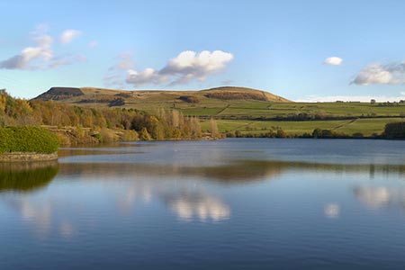
This Peak District walk starts from the village of Tintwistle on the A628 Woodhead Road and follows a series of paths around the three lowest reservoirs of the six that make up the Longendale Chain. At the time of their completion in 1877 the reservoirs formed the largest body of man-made water in the World.
Parking is available along Chapel Brow (grid ref. SK023973) alongside the cemetery wall. After parking, cross the A628 and go down the access road to the Longendale Environmental Centre. Turn right after a gate and then walk left following a sign to the 'Bottoms Path Concessionary' and continue down to the shore of the reservoir. Follow the path along the shoreline (with the reservoir to your right). The path is clear, and you soon pass the dam to Valehouse Reservoir.
The path is easy walking and the route straightforward with a fine view across the water to Bramah Edge. Nearing the dam wall for Rhodehouse Reservoir, take the steeply rising path on your left. This leads up to a road and the top of the dam wall. Turn left, cross the culvert and the take the next path on the right. Follow this path through to the dam wall for Torside Reservoir. Turn right across the top of the dam, joining a short section of the Pennine Way and continue to the far side. Follow the road to the left to turn sharp right onto the Longendale Trail just before the B6105.
You now have just under two miles of easy walking along the Longendale Trail. About halfway along Bottoms Reservoir with a few trees either side of the track turn right of the Trail (grid ref. SK031968) and follow the public footpath that leads half right across to fields to reach the reservoir shoreline. Turn left along the reservoir, with the water to your right, and continue on the shoreline path to reach the dam wall. Cross the dam and turn right up to the environmental centre. Turn left up to the A628 and the start of the walk is opposite.
Other walks nearby
| Walk 1703 | Longdendale from Hadfield Station | easy/mod | 9.0 miles |
| Walk 2521 | Hollingworthall Moor & Walkerwood Reservoirs | moderate | 7.0 miles |
| Walk 1759 | Torside Clough & Longendale from Old Glossop | moderate | 7.4 miles |
| Walk 1168 | Old Glossop & Bleaklow | moderate | 9.5 miles |
| Walk 2637 | Coombs Ridge, Cown Edge from Broadbottom | easy/mod | 7.0 miles |
| Walk 1686 | Cown Edge | easy/mod | 7.3 miles |
| Walk 2625 | Torside Clough from Longdendale | moderate | 4.5 miles |
| Walk 3027 | Bleaklow Head from Longdendale | moderate | 8.0 miles |
| Walk 1179 | Lad's Leap & Laddow Rocks from Crowden | moderate | 6.5 miles |
| Walk 2621 | Black Hill & Laddow Rocks | moderate | 9.0 miles |
Recommended Books & eBooks
Walking in Derbyshire
 Walking guidebook to 60 circular day walks in Derbyshire and the Peak District. Includes the Derwent, Wye and Trent river valleys, near Derby, Matlock, Glossop, Bakewell and Ripley. Routes range from easy to moderate and are between 4 and 14km (2 to 10 miles). Walks focus on places of interest, from Stone Age forts to castles to grand estates.
More information
Walking in the Peak District - White Peak East
 Guidebook describing 42 half-day and day walks in the limestone landscapes of Derbyshire's White Peak, part of the Peak District National Park. One of two volumes, this book covers the east of the region, with potential bases including Bakewell, Eyam, Castleton, Birchover, Matlock and Wirksworth.
More information
Messaging & Social Media
Message Walking Britain and follow the latest news.

Mountain Weather
Stay safe on the mountains with detailed weather forecasts - for iOS devices or for Android devices.