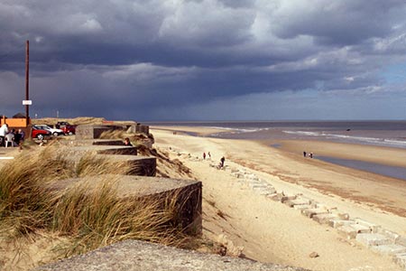
Winterton Ness from West Somerton
The Broads Walk
Nat Park - The Broads
County/Area - Norfolk
Author - Lou Johnson
Length - 5.4 miles / 8.8 km Ascent - 100 feet / 30 metres
Time - 2 hours 50 minutes Grade - easy
Maps 

| Ordnance Survey Explorer OL40 | Sheet Map | 1:25k | BUY |
| Anquet OS Explorer OL40 | Digital Map | 1:25k | BUY |
| Ordnance Survey Landranger 134 | Sheet Map | 1:50k | BUY |
| Anquet OS Landranger 134 | Digital Map | 1:50k | BUY |
Walk Route Description
Click image to see photo description.
This Norfolk walk starts from the village of West Somerton and can be extended by combing with walk 3608 to provide a longer walk. The route crosses countryside to reach the sea at Winterton Holmes followed by a walk along the dunes to Winterton. Here the route turns inland passing through East Somerton back to the start. The walk starts from the small gravel parking area at Martham Staithe (grid ref. TG468200) where there is a pleasant grassed area and seat adjacent to the moorings.
Leave the car park and turn right along Horsey Road. Continue along the road through a left-hand bend and walk as far as where the road bends right to take the signed footpath between houses on the right. Follow the path across a field to a stile and turn left onto The Street. The road soon becomes a track, bears to the right and then left to join Holmes Road at grid ref. TG475201 signposted to the Burnley Estate. After about half a mile take the footpath on the right. The path turns left and then right following the edge of a field to reach farm buildings at Winterton Holmes. With the farm buildings to your right, continue along the clear track to reach the sand dunes at Winterton Ness.
Turn right and follow the track along the dunes. After nearly a mile and a half the track joins a road. Turn right into Low Road. Continue straight ahead as the road becomes a track. Continue ahead to reach Manor Farm Road (grid ref. TG484196) and continue straight ahead. The road twists and turns through the village of East Somerton, passing Manor Farm on the left with a small pond by the roadside.
Continue ahead into woodland, looking out for the derelict St Mary's Church on your left, and walk past Burnley Hall (also on your left). Reaching a T-junction of tracks, turn right along a concrete track (Honeypot Lane) which bends to the left and re-joins the outward route at Holmes Road (grid ref. TG475201) where you retrace your steps back to the start.
Other walks nearby
| Walk 1855 | Horsey Circular | easy | 5.1 miles |
| Walk 1992 | Horsey Gap from Horsey | easy | 3.7 miles |
| Walk 3694 | River Thurne & Hickling Broad from Potter Heigham | easy/mod | 6.4 miles |
| Walk 2128 | Stokesby & Muck Fleet from Fleggburgh | easy | 7.1 miles |
| Walk 2129 | River Ant & How Hill from Ludham | easy | 6.7 miles |
| Walk 2839 | St Benet's Abbey & How Hill from Ludham | easy/mod | 8.8 miles |
| Walk 2320 | Muck Fleet & River Bure from near Oby | easy/mod | 8.7 miles |
| Walk 2239 | River Bure and Tunstall Dike from Acle | easy | 6.1 miles |
| Walk 2240 | The River Bure & Upton from Acle | easy | 5.0 miles |
| Walk 2297 | Honing & East Ruston Circular | easy/mod | 6.4 miles |
Recommended Books & eBooks
No suggestions for this area.Messaging & Social Media
Message Walking Britain and follow the latest news.

Mountain Weather
Stay safe on the mountains with detailed weather forecasts - for iOS devices or for Android devices.