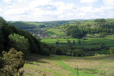
Panpunton Hill & Stowe from Knighton
Shropshire Hills Walk
Region - Shropshire Hills
County/Area - Shropshire
Author - Lou Johnson
Length - 7.8 miles / 12.7 km Ascent - 1300 feet / 394 metres
Time - 5 hours 10 minutes Grade - moderate
Maps 

| Ordnance Survey Explorer 201 | Sheet Map | 1:25k | BUY |
| Anquet OS Explorer 201 | Digital Map | 1:25k | BUY |
| Ordnance Survey Landranger 148 | Sheet Map | 1:50k | BUY |
| Anquet OS Landranger 148 | Digital Map | 1:50k | BUY |
Walk Route Description
Click image to see photo description.
This walk in the Shropshire Hills AONB starts from Knighton in Powys and explores the hills to the north of the market town. The route uses a section of the Offa's Dyke Path across Panpunton Hill before turning east to Stowe from where the return leg heads west.
The start is the free car park by the Offa's Dyke Visitor Centre on West Street (grid ref. SO284725). Exit the rear of the car park on the waymarked Offa's Dyke Path down steps to the bank of the River Teme. The path soon crosses the border into England and continues by the River to reach a bridge. After crossing the river, cross the railway with care and continue a short way along the river. Turn right, cross a minor road to a gate. Head through the gate and start a steep climb on the Offa's Dyke Path with trees to your right. Continue straight ahead across a track and continue beside a plantation which should be on your right.
Pass through a gate, continuing across Panpunton Hill. Pass a bench where you can enjoy the excellent view. Continue through another gate and follow the Offa's Dyke earthwork. Continue through two more gates, pass some buildings on your left to a gate providing access to a bridleway (grid ref. SO275491). Leaving the Offa's Dyke Path, turn right along the enclosed bridleway to a gate. Continue to reach a small wood on the right. From here the bridleway heads across to the far corner of the field. Continue ahead to the A488 at Five Turnings (grid ref. SO286754).
Go straight across the A488 and take the signed bridleway to the right of the cottage. This track will be followed for just over two kilometres passing through four gates along the way to reach another in trees (grid ref. SO306747). Continue ahead with a plantation on your left. Reaching a stile on your left after 750 metres, turn right passing a dried-up pond on your left. As you descend head for the gate in a fence to join a track which loses height through Holloway Rocks. Pass a pond on the right. The track forks just after the pond. Bear left and continue down the track to run beside a plantation on your left. Go through gate and continue down the track to pass St Michael's Church at Stowe on your right. Just beyond the church turn right down a tarmac lane (grid ref. SO310737).
Continue down the lane to where the lane bends left. Turn right onto a track (not the driveway with the cattle grid). Continue over a cattle grid to a house on the right. Turn left across a stream up the field to a gate. Turn right to a junction of tracks (grid ref. SO308734). Take the signed bridleway ahead into a field. The route follows the left-hand field boundary and passes through several gates to reach the A488 (grid ref. SO301729). Cross the road and take the stile slightly to the left on the opposite side of the road. Cross the small footbridge and continue to a stile at the edge of Kinsley Wood. Go up steps to a track and fork left. Then fork right onto a path. Go straight ahead at a junction and follow the path parallel to the road on your left. Reaching the A488, bear left to the railway station. Go left across the railway and continue to the town centre. Turn right into Broad Street to a clock tower. Take the road the tower's right and continue back to the start.
Other walks nearby
| Walk 2816 | Kinsley Wood, Stowe and Offa's Dyke | moderate | 12.0 miles |
| Walk 1907 | Stowe & Offa's Dyke from Kinsley Wood | moderate | 7.0 miles |
| Walk 3643 | LLan-fawr & Lugg Valley from Whitton | moderate | 7.5 miles |
| Walk 3050 | Clun circular | moderate | 11.5 miles |
| Walk 1998 | Harley's Mountain from Lingen | easy/mod | 7.5 miles |
| Walk 1785 | Newcastle on Clun circular | moderate | 7.5 miles |
| Walk 3023 | Great Rhos & the Radnor Forest from New Radnor | moderate | 9.0 miles |
| Walk 1673 | Shobdon Hill and Croft Ambrey from Shobdon Estate | moderate | 12.5 miles |
| Walk 3614 | Herrock Hill from Kington | moderate | 8.0 miles |
| Walk 3285 | The Hergest Ridge and Huntington from Kington | moderate | 12.0 miles |
Recommended Books & eBooks
Hillwalking in Shropshire
 Guidebook to 32 walking routes in Shropshire in the West Midlands. The routes range from 3 miles (5km) to 12 miles (19km), taking in highlights such as The Wrekin, Wenlock Edge, Long Mynd and Stiperstones, Castle Ring and Bury Ditches. Many routes start near delightful towns and villages including Church Stretton, Ludlow and Bishops Castle.
More information
Messaging & Social Media
Message Walking Britain and follow the latest news.

Mountain Weather
Stay safe on the mountains with detailed weather forecasts - for iOS devices or for Android devices.