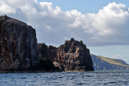
St. Abb's Head from St. Abbs
Scottish Borders Walk
County/Area - Scottish Borders
Author - Lou Johnson
Length - 4.2 miles / 6.8 km Ascent - 500 feet / 152 metres
Time - 2 hours 40 minutes Grade - easy
Maps 

| Ordnance Survey Explorer 346 | Sheet Map | 1:25k | BUY |
| Anquet OS Explorer 346 | Digital Map | 1:25k | BUY |
Walk Route Description
Click image to see photo description.
This coastal walk in the Scottish Borders starts from St. Abbs and follows the coastal footpath along a rugged coast to Kirk Hill passing the strategically placed lighthouse. The view west to the Firth of Forth is superb as is the retrospective view to St. Abbs and Eyemouth. The route continues around St. Abb's Head before turning inland to pass Mire Loch to follow quiet lanes back to the start. In season the St. Abb's Head National Nature Reserve is home to many birds.
The start is the St. Abb's Head National Nature Reserve pay and display car park which is located on the left as you approach St. Abbs on the B6438 (grid ref. NT913674). After parking exit the car park at the rear and turn left along the B6438 into St. Abbs. After 300 metres turn left on the signed path to St. Abb's Head. The path soon reached the coast and follows the cliff tops north along the rocky coast to reach Kirk Hill. Bear right following the Lighthouse Loop with purple arrows to reach the lighthouse and a topograph shortly after.
Turn left along the road and follow it downhill into a valley. Turn left onto the signed path "Mire Loop" which is waymarked with yellow arrows. Continue alongside the loch on your left to reach a stony track. Turn right and follow the track to a road (grid ref. NT912684). Continue straight ahead when you reach a road and continue back to the car park. After completing the walk follow the B6284 down into the fishing village of St. Abbs with its small harbour, which is worth exploring at leisure.
Other walks nearby
| Walk 1729 | Coldingham & Abbs Head | easy/mod | 7.2 miles |
| Walk 3356 | Dunbar circular from John Muir Country Park | easy/mod | 8.0 miles |
| Walk 1894 | Burnhope Reservoir Circular | easy | 2.8 miles |
| Walk 3242 | Holy Island - Lindisfarne Castle & Emmanuel Head | easy | 4.4 miles |
| Walk 3344 | Holy Island & Lindisfarne Castle Circular | easy | 4.3 miles |
| Walk 2677 | Circuit of Doddington Moor | easy | 3.8 miles |
| Walk 1314 | Great Hetha and Elsdon Burn from Hethpool | easy/mod | 4.0 miles |
| Walk 3644 | Blackhaggs Rigg & Great Hetha from Hethpool | moderate | 9.6 miles |
| Walk 3646 | Hethpool, Sutherland Bridge & Great Hetha | moderate | 6.0 miles |
| Walk 3739 | Elsdonburn & Trowupburn from Hethpool | moderate | 8.2 miles |
Recommended Books & eBooks
Walking in the Southern Uplands
 Guidebook to 44 varied day walks and over 100 summits in the Southern Uplands of Scotland, stretching south-west from Edinburgh to the English border, including the Galloway and Pentland Hills. Between 2 and 29km, there is something for all seasons and all abilities in remote and rugged hill country.
More information
The Borders Abbeys Way
 Guidebook to the Borders Abbeys Way, a 68 mile circuit in the Scottish Borders, taking in 4 of Britain's grandest ruined medieval abbeys. Beginning and ending in Tweedbank, the route, which is described over 6 stages, is as rich in history as it is in pastoral charm. Relatively flat, it is suitable for people with a moderate level of fitness.
More information
Messaging & Social Media
Message Walking Britain and follow the latest news.

Mountain Weather
Stay safe on the mountains with detailed weather forecasts - for iOS devices or for Android devices.