Hodbarrow Lagoon from Haverigg
Cumbria Walk
County/Area - Cumbria - South Cumbria
Author - Lou Johnson
Length - 4.2 miles / 6.8 km Ascent - 100 feet / 30 metres
Time - 2 hours 10 minutes Grade - easy
Maps 

| Ordnance Survey Explorer OL6 | Sheet Map | 1:25k | BUY |
| Anquet OS Explorer OL6 | Digital Map | 1:25k | BUY |
Walk Route Description
Click image to see photo description.
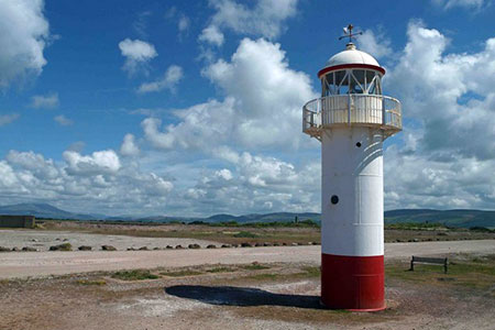
This Cumbria coastal walk from Haverigg explores the Hodbarrow Lagoon which is also home to a RSPB Nature Reserve. The area was once an important iron ore mining centre and the lagoon is a result of subsequent subsidence. The route follows a man-made barrier to pass the current Haverigg lighthouse to reach a former windmill. The walk then continues past the original lighthouse as it follows the northern shore of the lagoon.
The walk starts from the Sea View car park in Haverigg (grid ref. SD 160785). After parking, follow Sea View with the sea on your right. Follow this road round to the left and turn right across the bridge. Cross the bridge and turn right at the footpath fingerpost. Continue along the path which soon bends left along the back of the beach. The path soon re-joins the road and passes a parking area with the barrier in view ahead. Turn right onto the barrier following a clear track.
After just over a kilometre you pass the current lighthouse with the original lighthouse in view across the lagoon. Continue ahead along the track to reach the ruins of a windmill at Hodbarrow Point on your right. Turn left and follow a clear track around the eastern shore of Hodbarrow Lagoon to pass through Hodbarrow Nature Reserve. Continue along the tarmac lane skirting the northern shore of the lagoon. The lane swings to the left, bends right and then left to reach a T-junction. Turn right and follow the road back to the bridge in Haverigg. Turn left onto Sea View back to the start.
Other walks nearby
| Walk 2281 | White Combe FROM near Whicham | easy/mod | 4.5 miles |
| Walk 2271 | Black Combe from near Stoneside Hill | easy/mod | 6.3 miles |
| Walk 1301 | Great Stickle & Stickle Pike | moderate | 5.0 miles |
| Walk 3592 | Birkrigg Common and Bardsea | easy | 3.8 miles |
| Walk 1124 | Beacon Tarn & The Beacon from near Torver | easy/mod | 4.0 miles |
| Walk 1058 | Beacon Fell & Beacon Tarn Circular | easy/mod | 4.0 miles |
| Walk 1993 | Ravenglass & the Esk Estuary | easy | 3.4 miles |
| Walk 3110 | The Old Man of Coniston & Dow Crag from Torver | mod/hard | 8.5 miles |
| Walk 1668 | Silver Knott & Muncaster Fell from Irton Road | easy/mod | 5.0 miles |
| Walk 3638 | Satterthwaite Bridge Circular | easy | 3.2 miles |
Recommended Books & eBooks
Walking the Lake District Fells - Patterdale
 Part of the Walking the Lake District Fells series, this guidebook covers a wide range of routes to 35 Lakeland summits that can be climbed from Ambleside, Grasmere and Patterdale and the Thirlmere and Ullswater valleys, with highlights including Helvellyn and Fairfield. Suggestions for longer ridge routes are also included.
More information
Walking the Lake District Fells - Mardale and the Far East
 Part of the Walking the Lake District Fells series, this guidebook covers a wide range of routes to 36 Lakeland summits that can be climbed from the Ullswater, Haweswater, Troutbeck, Kentmere and Longsleddale valleys, with highlights including High Street, Place Fell and the Kentmere fells. Suggestions for longer ridge routes are also included.
More information
Messaging & Social Media
Message Walking Britain and follow the latest news.

Mountain Weather
Stay safe on the mountains with detailed weather forecasts - for iOS devices or for Android devices.