Scar House Reservoir, Dale Edge & Middlesmoor
Nidderdale AONB Walk
Region - Nidderdale AONB
County/Area - North Yorkshire - Nidderdale AONB
Author - Lou Johnson
Length - 9.0 miles / 14.6 km Ascent - 1400 feet / 424 metres
Time - 5 hours 50 minutes Grade - moderate
Maps 

| Ordnance Survey Explorer 298 | Sheet Map | 1:25k | BUY |
| Anquet OS Explorer 298 | Digital Map | 1:25k | BUY |
Walk Route Description
Click image to see photo description.
This North Yorkshire walk from Middlesmoor in Nidderdale completes a circuit around the lip of Nidderdale offering fine views across the beautiful valley and surrounding moorland. The route follows tracks and paths and includes Scar House Reservoir, uses sections of the Nidderdale Way, and descends to the River Nidd on the return leg back to Middlesmoor.
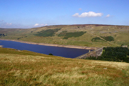
The start is the small car park at the northern end of Middlesmoor village (grid ref. SE092743). After parking exit the car park and turn right to join the Nidderdale Way which heads northwest. The route follows In Moor Lane for four kilometres to reach Scar House Reservoir. The route climbs steadily across the moor before descending to the shore of Scar House Reservoir (grid ref. SE064766).
Turn right along the reservoir still following the Nidderdale Way and then bear left across the dam. Once across the dam, the route climbs away from the reservoir and then turns right onto Carle Fell Road (grid ref. SE065772). Follow this clear track across the hillside for just over 1.5 kilometres to cross Woo Gill (grid ref. SE078777). 500 metres beyond Woo Gill where the Nidderdale Way forks right, bear left and climb past the Shooting House to reach a T-junction with a clear track (grid ref. SE085779).
Bear left along the track with fine views into Nidderdale on your right. Continue ahead on this track around Dale Edge for approximately five kilometres to reach another Shooting House (grid ref. SE102751). Turn right just before the Shooting House and continue down towards Thorpe Farm (grid ref. SE102751) where you meet the Nidderdale Way.
Turn right and just past the farm (on your left) turn left and descend to cross the River Nidd (grid ref. SE101751). Turn left and follow the path south with the river on your right. After 150 metres fork half right at a path junction and follow the rising path heading south-west back to Middlesmoor. The path passes through a small plantation, crosses Intake Gill, and reaches the road at the southern end of Middlesmoor near the Parish Church. Reaching the road, turn right through the village back to the car park.
Other walks nearby
| Walk 2572 | West Scrafton & Middlesmoor from Lofthouse | mod/hard | 18.0 miles |
| Walk 1571 | Scar House & Angram Reservoirs | easy | 4.0 miles |
| Walk 2406 | Ripon Rowel Walk Leg 4 - Ilton to Grewelthorpe | moderate | 10.5 miles |
| Walk 1573 | Grimwith Reservoir | easy | 4.5 miles |
| Walk 2261 | Pateley Bridge & Nidderdale Way | easy/mod | 7.1 miles |
| Walk 1250 | Great Whernside | moderate | 8.0 miles |
| Walk 1277 | Starbotton & Kettlewell circular | easy/mod | 5.0 miles |
| Walk 1294 | Arncliffe & Kettlewell Circular | moderate | 7.0 miles |
| Walk 1632 | Arncliffe & Starbotton from Kettlewell | moderate | 7.0 miles |
| Walk 2610 | Hebden Gill & Cupola Corner | easy/mod | 6.5 miles |
Recommended Books & eBooks
Trail and Fell Running in the Yorkshire Dales
 Guidebook to 40 of the best trail and fell runs in the Yorkshire Dales National Park. Ranging from 5 to 24 miles, the graded runs start from bases such as Ribblehead, Dent, Sedbergh, Malham and Grassington and take in the region's diverse delights, from castles and waterfalls to iconic mountains such as Whernside, Ingleborough and Pen Y Ghent.
More information
Messaging & Social Media
Message Walking Britain and follow the latest news.

Mountain Weather
Stay safe on the mountains with detailed weather forecasts - for iOS devices or for Android devices.