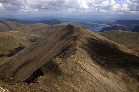
Catstye Cam from Glenridding
Lake District Walk
Nat Park - Lake District - Lake District Eastern Fells
Wainwrights - Catstye Cam
County/Area - Cumbria
Author - Lou Johnson
Length - 7.0 miles / 11.4 km Ascent - 2400 feet / 727 metres
Time - 5 hours 50 minutes Grade - mod/hard
Maps 

| Ordnance Survey Explorer OL5 | Sheet Map | 1:25k | BUY |
| Anquet OS Explorer OL5 | Digital Map | 1:25k | BUY |
Walk Route Description
Click image to see photo description.
The summit of Catstye Cam offers an excellent objective for a Lake District walk. Despite its proximity to Helvellyn, few walkers visit this hill so you can have an enjoyable walk away from the masses. The summit is linked to Helvellyn by Swirral Edge and offers a grand view over Red tarn to Striding Edge.
The start is the main pay and display car park in Glenridding (grid ref. NY386169) which can be very busy on fine days and at weekends. After parking walk to the north side of the car park and turn left into Greenside Road by the Fairlight Guest House. Follow Greenside Road for two kilometres climbing steadily to reach Helvellyn Youth Hostel (grid ref. NY366174). Follow the gravel track over Swart Beck. Reaching the track to Red Tarn that goes straight ahead, bear left, and follow the path uphill past quarry tips. Stay on the main valley track with Glenridding Beck below on your left.
Stay on this track, cross Rowten Beck using the footbridge and continue to reach a junction of paths (grid ref. NY352166) after a further 800 metres. Veer left and continue to reach a disused dam (grid ref. NY346164). Do not cross the dam but keep to the left of the sheepfold and descend to cross a stream. Once across the stream follow a narrow path with a stream and the lower slopes of Catstye Cam on your right.
Find a suitable place to cross the stream and start a pathless ascent across rough ground for 150 metres to reach the base of the north-west ridge. You now have a steep climb over loose, pathless ground. Take care as although the route is not exposed some steep crags are passed. As height is gained a feint path can be followed and this leads to the summit of Catstye Cam.
The summit offers a superb panorama including Helvellyn, Striding Edge and a great view down to Glenridding. After enjoying the view descend south-east and shortly after bear left along a clear descending path across the eastern flank of Catstye Cam. The path leads down to the main path from Red Tarn. Cross two footbridges and continue down to a third footbridge (grid ref. NY363173).
Do not cross this bridge and continue on the path for 1.4 kilometres to where the path forks. Bear left on a narrower path with a wall on your left to reach a path junction. Go through the gate ahead, turn left and follow path which leads onto a road. Follow the road through the campsite back to Glenridding.
Other walks nearby
| Walk 1230 | Birks & Arnison Crag | moderate | 5.5 miles |
| Walk 1520 | Helvellyn & Fairfield Horseshoe from Patterdale | very hard | 13.0 miles |
| Walk 2047 | Place Fell | moderate | 7.5 miles |
| Walk 2425 | Boredale Circular from Patterdale | mod/hard | 11.5 miles |
| Walk 3670 | Angle Tarn and Hayeswater | moderate | 8.3 miles |
| Walk 1110 | Angletarn Pikes | moderate | 7.0 miles |
| Walk 2060 | The Angletarn Pikes and Brock Crags from Hartsop | moderate | 8.0 miles |
| Walk 3388 | Hayeswater and Angle Tarn from Hartsop | mod/hard | 11.5 miles |
| Walk 2386 | Red Screes via Dove Crag | mod/hard | 8.6 miles |
| Walk 2039 | Gowbarrow Fell circular | moderate | 3.5 miles |
Recommended Books & eBooks
Hadrian's Wall Path
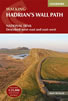 Hadrians Wall Path guidebook to walk the 84 mile National Trail. Described in both directions, the main description is west to east between Bowness-on-Solway and Wallsend, Newcastle, with extensions to Maryport and South Shields. With extensive historical information related to this World Heritage site and separate 1:25,000 OS map booklet included.
More information
Lake District: High Level and Fell Walks
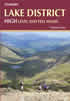 This guidebook describes 30 graded fell walks on the ridges and high peaks of the English Lake District, the UK's most popular national park. Reaching some of England's finest and highest mountain scenery, this guide leads readers to classic horseshoes and traditional ascents as well as lesser-known routes to quieter summits.
More information
Messaging & Social Media
Message Walking Britain and follow the latest news.

Mountain Weather
Stay safe on the mountains with detailed weather forecasts - for iOS devices or for Android devices.