Blabheinn via south ridge
Highland Walk
County/Area - Highland - Isle of Skye
Author - Lou Johnson
Length - 8.0 miles / 13 km Ascent - 3400 feet / 1030 metres
Time - 7 hours 20 minutes Grade - mod/hard
Maps 

| Ordnance Survey Explorer 411 | Sheet Map | 1:25k | BUY |
| Anquet OS Explorer 411 | Digital Map | 1:25k | BUY |
Walk Route Description
Click image to see photo description.
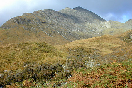
A walk to the summit of Blabheinn, a Munro rising to 929 m. above sea level is said by some to be the finest hill on Skye. In particular the view from the east along the road to Elgol shows the magnificent grandeur of this peak, which is the most dominant of the Cuillin outliers. The route of ascent starts with easy walking along a moorland track before turning north to make an ascent up the south ridge.
The start is the small layby (grid ref. NG545172) on the road to Elgol about 500 metres beyond the turn off for Kilmarie. After parking cross the road to the gate and stile to join a track crossing a rugged moorland landscape. Along the way several burns are crossed as you make easy progress. To you right is Slat Bheinn which dominates the scene as you head towards Am Mam col marked by a cairn. The view ahead opens up to the Black Cuillin and you also get you first view of Blabheinn's south ridge.
The track veers north with a view across Camasunary bay below and Glen Sligachan ahead. Just before a hairpin bend in the track, bear right at a small cairn onto a small path that soon crosses Adhainn na Leac (grid ref. NG523194). Shortly after crossing the stream, turn right off the path and start the ascent of the ridge. The onward route twists and turns up the ridge avoiding rocky outcrops and gullies. If you wish, you can tackle the outcrops head on as the scrambling is rewarding and not too difficult.
As you gain height the initial grassy nature of the ridge leads becomes rockier. The path avoids all difficulties and leads to the to a large cairn on the southern summit. To continue to the north summit requires a 15-metre descent across a ledge which requires a head for heights and scrambling experience. If this is beyond your capabilities, then be satisfied with the view from the South Summit before retracing your steps down the ridge and back to the start. If you have the necessary ability, then head up the north summit which is the highest point of the hill. On return the 15- metre scramble is less daunting.
Other walks nearby
| Walk 1166 | Loch Coruisk | easy | 4.0 miles |
| Walk 2589 | Marsco | moderate | 8.7 miles |
| Walk 2197 | The Inaccessible Pinnacle and Sgurr Mhic Choinnich | very hard | 6.0 miles |
| Walk 1167 | Glen Brittle & Coire Lagan | moderate | 4.6 miles |
| Walk 3760 | Glamaig (Sgurr Mhairi & An Coileach) | mod/hard | 4.5 miles |
| Walk 3216 | Sgurr a'Ghreadaidh and Sgurr na Banachdich | very hard | 5.5 miles |
| Walk 2002 | Dun Caan, Isle of Raasay | moderate | 10.6 miles |
| Walk 1886 | Carn a' Bhealaich Mhoir | easy/mod | 8.0 miles |
| Walk 1164 | The Storr Sanctuary | easy/mod | 3.2 miles |
| Walk 2640 | The Storr & Old Man of Storr | moderate | 5.5 miles |
Recommended Books & eBooks
Great Mountain Days in Scotland
 Inspirational guidebook to 50 challenging routes for mountaineers, scramblers, hillwalkers and fell runners, many long enough to backpack over 2 days, especially in winter (12 to 25 miles). A mix of classic routes and unsung gems across Scotland from Galloway to the Outer Hebrides in widely differing wild landscapes. With customised OS mapping.
More information
Walking the Munros Vol 2 - Northern Highlands and the Cairngorms
 Guidebook to walking the northern Munros, covering the northern Highlands, the Cairngorms and the Isle of Skye. 70 routes are described, including those up Ben Macdui, Braeriach and Cairn Gorm. Routes range from 7 to 46km, requiring a fair level of fitness. The second of two guidebooks to walking Scotland's Munros: peaks higher than 3000ft.
More information
Messaging & Social Media
Message Walking Britain and follow the latest news.

Mountain Weather
Stay safe on the mountains with detailed weather forecasts - for iOS devices or for Android devices.