Walk 5050 - printer friendly version
Craoghanmoira Mountain from the Ow River Walk
Author - Lou Johnson
Length - 7.5 miles / 12.2 km
Ascent - 1420 feet / 430 metres
Grade - moderate
The Wicklow Mountains are within an hours drive of Dublin and offer some fine routes. Rounded whalebacks predominate with excellent views often with glimpses of the Irish Sea especially on the eastern hills. Paths are not generally signed and can be hard to follow on the ground so some map reading and navigational skills are essential especially if poor visibility is likely to be encountered.
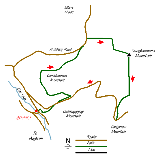
This walk starts at the small car park (grid ref. T072848) in the upper forested reaches of the Ow River valley some five miles (8 kilometres) northwest from Aughrim (Co. Wicklow). This area is at the southernmost end of the Wicklow Mountains and the view south is superb on days of good visibility.
From the car park locate the clearly signed Wicklow Way and follow the waymarked route north as it heads along the northern banks of Mucklagh Brook. You soon reach a road and this is followed for about 400 metres before the Wicklow Way heads left and begins to climb through a conifer plantation. The ascent is easy and continues for some way to reach the Military Road and open hillside (grid ref. T086870). The climb continues on this scenic but quiet road until you are level with the northern edge of the plantation on your right. Alongside the plantation is a path with climbs steadily across the hillside in an easterly direction to meet a path joining from your left, which comes in from the summit col of the Military Road.
Stay on the main path with the summit of Craoghanmoira Mountain ahead. With all the uphill work almost over you can enjoy the ever improving views as you gain height. At 664m it is the 23rd highest peak in the Wicklow Mountains. The summit is marked by a trig point and is notable for the panoramic view over all the major peaks in the area, which fill a wide northern arc from west to northeast. Like much of the area you are unlikely to see many other walkers and the chances of having the summit to yourself are good.
Having taken in the view the descent follows a path heading almost due south along the eastern boundary of a conifer plantation. This will lead you to a road. Turn right and follow the road back to the car park beside the River Ow. Fortunately traffic is almost non-existent so road walking is a pleasurable pastime in these parts!
Messaging & Social Media
Message Walking Britain and follow the latest news.

Mountain Weather
Stay safe on the mountains with detailed weather forecasts - for iOS devices or for Android devices.