Dodman Point & Gorran Haven from Caerhays
Cornwall AONB Walk
Region - Cornwall AONB
County/Area - Cornwall
Author - Lou Johnson
Length - 11.0 miles / 17.9 km Ascent - 2050 feet / 621 metres
Time - 7 hours 30 minutes Grade - mod/hard
Maps 

| Ordnance Survey Explorer 105 | Sheet Map | 1:25k | BUY |
| Anquet OS Explorer 105 | Digital Map | 1:25k | BUY |
| Ordnance Survey Landranger 204 | Sheet Map | 1:50k | BUY |
| Anquet OS Landranger 204 | Digital Map | 1:50k | BUY |
Walk Route Description
Click image to see photo description.
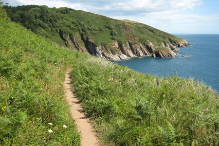
This Cornwall walk proves that coastal walking is not an easy option and it will take you most of a day especially if you stop for lunch in Gorran. It is a walk of contrasts with the outward section following a dramatic section of the South West Coast Path returning through typical rolling Cornish countryside.
The start is the small car park (Grid ref. SW 973413) close by Caerhays Castle. After parking exit onto the road and turn right across the bridge. Leave the road along the signed coastal footpath, which climbs beside the eastern side of the beach. It is a steep start but at least provides an idea of what is to come later in the walk! Looking back you have a fine view of Caerhays Castle and its grounds although it is inevitable that you will be looking ahead to see what the coastal path has in store.
Having gained some height you descend to Lambsowden Cove before another steep ascent to Greeb Point from with the scenery improving all the time. A level section allows you to relax before a descent takes you down to Hemmick Beach, which is usually quiet and away from the crowds. Dodman Point lies ahead with its highest point 374 feet above sea level. Having made a start on the ascent it comes as a surprise to learn that the initial gain in height is lost as you drop down to Gell Point where the view across Veryan Bay is of particular beauty.
Staying with the coastal path ignore the choice of heading inland at Collars Road and make for the giant cross that was erected in 1896 on Dodman Point. With views both ways along the coast it provides a good place to linger, perhaps enjoying a snack of drink as you absorb the view. Turning north the view ahead is to St. Austell Bay and on the occasion the route was researched this next section was home to a family of adders who soon writhed into the undergrowth!
The descent to Bow Beach allows a breather in readiness for a short climb to Maenease Point from where it is only a short way to Gorran Haven where a number of cafes are available for refreshments. Pressing on, head north out of Gorran Haven bearing right along Cliff Road. This leads you onto the coastal path and the section that skirts Great Perhaver Beach. Ahead lies Chapel Point and just before reaching it you can see Mevagissey ahead.
Reaching the main road in Portmellon head north turning right up a road with modern bungalows. Near the top of this road locate a farm track to Penwarne Farm. Go through the farmyard keeping the farmhouse on your left and go through a metal gate. The onward path stays on the north side of a valley contouring the hillside. Reaching Galowras Mill, cross the bridge and climb the track leading south. On your right you will find a fingerpost to Gorran Churchtown. Follow this path climbing steeply through a Nature Reserve. Sadly like many rural footpaths the waymarking leaves much to be desired and careful navigation is required using the 1:25000 map if you are to arrive correctly in Gorran Churchtown.
Leaving the woodland the path descends to cross a stream before climbing steeply again with Gorran church ahead. Exit the churchyard and walk up past the pub, which is on your left. Reaching the Post Office locate the path on your left and follow this across fields and a lane to reach a second lane from where you continue down a lane to Treveor Farm. After passing the farm, this quiet lane drops down quite steeply. Just before the lane bends right take the footpath on your left to Tregavarras. This leads across a field to a bridge and another field to reach a lane. Stay on this lane heading southwest to Tregavarras. Where the lane turns sharp left, take the footpath on your right. The end of many walks are an anticlimax but this last section provides a fitting finale to a superb walk with a splendid view of Caerhays Castle and Veryan Bay. Reaching the road, turn left across the bridge to the start of the route.
Other walks nearby
| Walk 1783 | Gorran Haven & Dodman Point | easy/mod | 5.0 miles |
| Walk 1027 | Nare Head & Portloe | moderate | 7.0 miles |
| Walk 2003 | Cowlands, Coombe & Roundwood Quay from Trelissick | easy/mod | 9.0 miles |
| Walk 3112 | Soar Mill Cove & Bolt Head from Higher Soar | easy/mod | 6.5 miles |
| Walk 1030 | Fowey & Gribbin Head | moderate | 8.0 miles |
| Walk 2342 | Gribbin Head & Polkerris from Polruan | moderate | 8.5 miles |
| Walk 1031 | Polruan & Lanteglos Church | easy/mod | 4.3 miles |
| Walk 2088 | Rosemullion Head & Mawnan | easy | 4.0 miles |
| Walk 2007 | Helford Passage & Frenchman's Creek | easy/mod | 7.0 miles |
| Walk 2009 | Gillan & Nare Point from Porthallow | easy | 4.7 miles |
Recommended Books & eBooks
South West Coast Path Map Booklet - St Ives to Plymouth
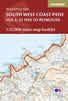 Map of part of the southern section of the 630 mile (1014km) South West Coast Path National Trail. Covers the trail from St Ives to Plymouth along the west Cornwall and Devon coastline. This convenient and compact booklet of Ordnance Survey 1:25,000 maps shows the route, providing all of the mapping you need to walk the trail in either direction.
More information
The South West Coast Path
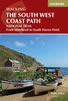 Guidebook to walking the entire South West Coast Path National Trail. The route runs for 630 miles from Minehead to Poole along the north Devon, Cornish, south Devon and Dorset coastline. Divided into 45 stages, this long-distance coastal trek could be completed within 4 weeks, or walked in sections. Guide includes maps and essential information.
More information
Messaging & Social Media
Message Walking Britain and follow the latest news.

Mountain Weather
Stay safe on the mountains with detailed weather forecasts - for iOS devices or for Android devices.