Harter Fell & Nan Bield Pass from Mardale Head
Lake District Walk
Nat Park - Lake District - Lake District Far Eastern Fells
Wainwrights - Harter Fell
County/Area - Cumbria
Author - Lou Johnson
Length - 4.5 miles / 7.3 km Ascent - 1800 feet / 545 metres
Time - 4 hours 0 minutes Grade - moderate
Maps 

| Ordnance Survey Explorer OL5 | Sheet Map | 1:25k | BUY |
| Anquet OS Explorer OL5 | Digital Map | 1:25k | BUY |
| Ordnance Survey Landranger 90 | Sheet Map | 1:50k | BUY |
| Anquet OS Landranger 90 | Digital Map | 1:50k | BUY |
Walk Route Description
Click image to visit gallery of 3 images.
This is a Lake District short walk ideal for a morning or afternoon excursion into the Lakeland Fells. As on this occasion it is also ideal for a window of good weather on an otherwise poor day. The start is the small carpark at the western end of Haweswater Reservoir (Grid ref. NY468107) and includes a relatively easy ascent of Harter Fell (the Mardale version not the Eskdale variety!) with a superb walk down from Nan Bield Pass back to the start.
After parking take the track signed Gatescarth Pass. This bridleway heads roughly south-east climbing easily with the steep crags of Harter Fell rising on your right and the smoother slopes of Branstree on your left. During the climb it is worth looking back as the view across Mardale to the High Street Fells improves as you climb with Rough Crag and the Long Stile ridge dominating the picture.
Reaching the summit of Gatescarth Pass turn right continuing to climb. The path skirts Little Harter Fell before steepening somewhat to gain height more rapidly. Just after the path turns left the view down into Mardale is superb although many people intent on reaching the summit miss it completely!
The summit of Harter Fell is not very inspiring being rather too flat to offer a great view. The descent to Nan Bield Pass is cairned and begins heading west from the summit cairn. It is a steep descent in places offering an excellent view across the pass to Mardale Ill bell and beyond. Down to your right Small Water comes into view with larger Blea Water to its left under the eastern crags of High Street.
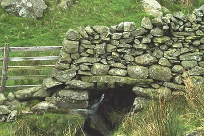
Reaching the stone shelter at Nan Bield Pass turn right and follow the clear path that descends to the shores of Small Water. This is superb Lakeland scenery with many crags and interesting mountain cameos. Cross Small Water Beck as it leaves the tarn and follow it down past some small but beautiful waterfalls. All too soon you are back at Mardale Head. Before leaving take a look back to Harter Fell and admire the crags - it is one Lakeland view that's certainly worth a second look .....
Other walks nearby
| Walk 1152 | The Corpse Road and Selside Pike | moderate | 6.0 miles |
| Walk 3033 | Tarn Crag & Harrop Pike from Sadgill | moderate | 5.5 miles |
| Walk 1147 | Longsleddale and Kentmere Pike | moderate | 8.0 miles |
| Walk 1228 | Thornthwaite Beacon & High Street | moderate | 6.5 miles |
| Walk 1959 | Gray Crag and Pasture Beck from Hartsop | moderate | 5.5 miles |
| Walk 2585 | Hartsop Dodd, Stony Cove Pike, High St. & The Knott | mod/hard | 10.0 miles |
| Walk 3309 | Hartsop, Hartsop Dodd, Stony Cove Pike & Kirkstone Pass | moderate | 8.5 miles |
| Walk 2488 | Shipman Knotts & Kentmere Pike | moderate | 6.2 miles |
| Walk 1320 | Shorter Kentmere Horseshoe | mod/hard | 10.5 miles |
| Walk 2652 | Photographer's Kentmere Horseshoe | mod/hard | 13.5 miles |
Recommended Books & eBooks
The Cumbria Way
 A guidebook to the 73 mile Cumbria Way, an easy long-distance walk though the heart of the Lake District National Park, from Ulverston in the south to Carlisle in the north, with good transport links to either end. The route is largely low-level but this guide offers alternative mountain days to climb some of the famous fells en route.
More information
Hadrian's Wall Path
 Hadrians Wall Path guidebook to walk the 84 mile National Trail. Described in both directions, the main description is west to east between Bowness-on-Solway and Wallsend, Newcastle, with extensions to Maryport and South Shields. With extensive historical information related to this World Heritage site and separate 1:25,000 OS map booklet included.
More information
Messaging & Social Media
Message Walking Britain and follow the latest news.

Mountain Weather
Stay safe on the mountains with detailed weather forecasts - for iOS devices or for Android devices.