Walk 1214 - printer friendly version
Carrock Fell & High Pike from Mosedale Walk
Author - Lou Johnson
Length - 7.0 miles / 11.4 km
Ascent - 1750 feet / 530 metres
Grade - moderate
Start - OS grid reference NY353337
Lat 54.69416 + Long -3.0053205
Postcode CA7 8JS (approx. location only)
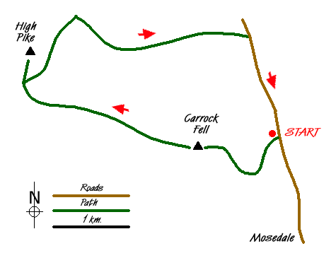
This Lake District walk explores the most northerly fells of Lakeland together with some of the open common land on the periphery of the National Park. In addition the route offers an insight in some of the mining activity that once thrived in this area. Do not expect rocky terrain, crags or lofty summits. Instead enjoy pleasant walking, good views and grass under your feet on some sections of the route. The start is near Mosedale and takes a direct line of ascent to the summit of Carrock Fell before staying on high ground to visit the summit of High Pike. The return route descends to follow Carrock Beck back to the start.
The start (Grid ref. NY353337) is near to Stone Ends Farm on the minor road going north from Mosedale towards Hesket Newmarket. There is plenty of space for parking on the grass verge of this common land. You should park to the north of the small beck, Further Gill Sike, coming off the fell. After careful inspection of the slope ahead, you should be able to see the path climbing steeply from right to left across the fellside just to the left of the crags. The path is most obvious where it crosses a section of light-coloured scree. Having located the path, climb steeply with the scree not causing any major problems. Reaching the beck, the path turns and follows the beck onto the open fell. The path continues making a bee-line for the eastern summit outcrop before continuing towards the main summit which is topped by a substantial cairn. The view is wide ranging covering the Pennines, the Vale of Eden and many Lakeland Fells.
To continue, walk west on a clear path passing Round Knott and Miton Hill towards the main track coming up across the flank of Low Pike from Wood Hall. Reaching this track, turn right and shortly after bear left to follow the clear path to the summit of High Pike with its stone bench and trig point. From here the view north across the Solway Firth to Scotland is full of interest. The view south is a surprise with Scafell, Scafell Pike, Esk Pike, Bow Fell and Crinkle Crags all in view.
Descend from High Pike by retracing your steps to the main track. Turn sharp left and start to descend northeast across the flank of High Pike. Reaching a junction of tracks (Grid ref. NY324354) turn right and descend past the old mine workings of Driggeth Mine towards Carrock Beck. Stay on this track to reach another junction (Grid ref. NY341351) where you bear right to follow the track nearest the beck. This leads to the tarmac lane (Grid ref. NY349351). Turn right along the lane, using the new footbridge by the Ford, and continue along the grass verge back to where you have parked. On the way back you may meet some of the wild ponies. On occasions they can be too friendly having been fed by some people passing this area.
Messaging & Social Media
Message Walking Britain and follow the latest news.

Mountain Weather
Stay safe on the mountains with detailed weather forecasts - for iOS devices or for Android devices.