Walk 1277 - printer friendly version
Starbotton & Kettlewell circular Walk
Author - Lou Johnson
Length - 5.0 miles / 8.1 km
Ascent - 850 feet / 258 metres
Grade - easy/mod
Start - OS grid reference SD968723
Lat 54.146518 + Long -2.0504846
Postcode BD23 5QZ (approx. location only)
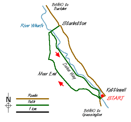
This easy Yorkshire Dales walk covers the section of Wharfedale from Kettlewell to Starbotton. The outward leg climbs up the valley side and offers excellent views along the length of the dale before dropping down to visit the small village of Starbotton. The return route follows the Dales Way National Trail as it follows the River Wharfe.
There is a pay and display car park in Kettlewell (Grid ref. SD 968723). Leave the car park and cross the River Wharfe. Ignore the first footpath on the right to take the next signed path. After a short way a path goes left. Ignore this and continue along the rough track that climbs steadily uphill. progress is relatively easy and you arrive at Moor End now used as an outdoor recreation centre.
Go to the left of the buildings and after a short way turn right down the signed path to Starbotton. After descending through pleasant woodland you reach a footbridge over the Wharfe. Cross this and follow the walled lane into Starbotton village. After exploring this pretty village return to the footbridge over the Wharfe. Cross the bridge and turn left. You are now on the Dales Way and this followed all the way back to Kettlewell.
Messaging & Social Media
Message Walking Britain and follow the latest news.

Mountain Weather
Stay safe on the mountains with detailed weather forecasts - for iOS devices or for Android devices.