Farndale Circular from Little Blakey
North York Moors Walk
Nat Park - North York Moors - North York Moors West
County/Area - North Yorkshire
Author - Andy Chaplin
Length - 12.0 miles / 19.5 km Ascent - 1195 feet / 362 metres
Time - 7 hours 10 minutes Grade - moderate
Maps 

| Ordnance Survey Explorer OL26 | Sheet Map | 1:25k | BUY |
| Anquet OS Explorer OL26 | Digital Map | 1:25k | BUY |
| Ordnance Survey Landranger 94 | Sheet Map | 1:50k | BUY |
| Anquet OS Landranger 94 | Digital Map | 1:50k | BUY |
Walk Route Description
Click image to see photo description.
This is one of the simplest walks to follow in the North York Moors National Park but gives spectacular views of Farndale, Westerdale and Rosedale. Apart from the initial crossing of Farndale it is also relatively level - so the hard work all comes at the start and subsequently it is just a lengthy stroll across the moors.
From the car park at Little Blakey (grid ref SE683989), which is just past the Lion Inn, take the road opposite down to Church Houses. Turn right when you enter the village, then left around the Feversham Arms Inn and take the road opposite its rear door down towards the River Dove. Carry on uphill to Daleside Road, turn right at the top (on what appears to be another Daleside Road) then take the track off on the left opposite Monket House (grid ref SE660972).
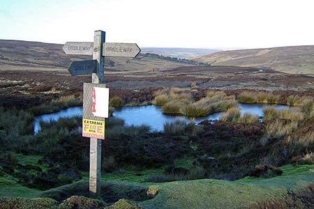
Carry on uphill on the track for about 2 km until there are views over into Bransdale ahead of you. At the intersection of tracks turn right on the Westside Road track and follow it northwards past the disused quarry on your right. After 4.75 km you arrive at Bloworth Crossing with a Cleveland Way sign showing the CW routes off to the left and straight ahead.
Take the old Battersby to Rosedale Head railway line off on the right and follow it around the north of Farndale Head and the south of Westerdale Head. The walk back from Bloworth Crossing to the parking at Blakey is just over 9 km of easy walking with great views of both the Farndale and Westerdale valleys.
Other walks nearby
| Walk 1921 | Spaunton Moor from Chimney Bank | easy/mod | 8.1 miles |
| Walk 2077 | Glaisdale Moor circular | moderate | 11.9 miles |
| Walk 1542 | The Rudland Ridge from Ousegill Bridge | moderate | 10.1 miles |
| Walk 3187 | Esklets and Rosedale Head from Westerdale | moderate | 11.0 miles |
| Walk 2029 | Lastingham & Rosedale from Hutton-le-Hole | moderate | 12.0 miles |
| Walk 1538 | Baysdale Circular | moderate | 9.5 miles |
| Walk 1450 | Little & Great Fryup Dales | moderate | 8.3 miles |
| Walk 3398 | Rollgate Bank & Aumery Park from Fadmoor | moderate | 11.0 miles |
| Walk 3737 | Commondale & Esk Valley | easy/mod | 8.2 miles |
| Walk 1675 | The Esk Valley & Egton High Moor | moderate | 10.5 miles |
Recommended Books & eBooks
The Cleveland Way Map Booklet
 Map booklet of the Cleveland Way National Trail, a 177km (110 mile) walk around the North York Moors National Park. This booklet is included with the Cicerone guidebook to the Cleveland Way and the Yorkshire Wolds Way, and shows the full route of the Cleveland Way on Ordnance Survey 1:25,000 maps.
More information
Trail and Fell Running in the Yorkshire Dales
 Guidebook to 40 of the best trail and fell runs in the Yorkshire Dales National Park. Ranging from 5 to 24 miles, the graded runs start from bases such as Ribblehead, Dent, Sedbergh, Malham and Grassington and take in the region's diverse delights, from castles and waterfalls to iconic mountains such as Whernside, Ingleborough and Pen Y Ghent.
More information
Messaging & Social Media
Message Walking Britain and follow the latest news.

Mountain Weather
Stay safe on the mountains with detailed weather forecasts - for iOS devices or for Android devices.