Wavering Down & Crook Peak from Winscombe
Somerset Walk
County/Area - Somerset
Author - Lou Johnson
Length - 6.0 miles / 9.8 km Ascent - 900 feet / 273 metres
Time - 3 hours 50 minutes Grade - easy/mod
Maps 

| Ordnance Survey Explorer 141 | Sheet Map | 1:25k | BUY |
| Anquet OS Explorer 141 | Digital Map | 1:25k | BUY |
| Ordnance Survey Landranger 172 | Sheet Map | 1:50k | BUY |
| Anquet OS Landranger 172 | Digital Map | 1:50k | BUY |
Walk Route Description
Click image to see photo description.
This pleasant walk in the Mendips provides some wonderful views and good exercise. The start is the car park on a minor road just off the A38 at grid ref. ST421560 roughly half way between Axbridge and Winscombe. The route is generally easy to follow but do remember to save some energy as the last section from Cross village back to the car park is mostly uphill.
After parking, walk uphill along the West Mendip Way in a westerly direction. This path marked as a bridleway on OS maps leads you steadily uphill, initially through woodland, up to Hill Farm, which is on your right. Continue in the same direction ascending more steeply onto Wavering Down. You will pass the trig point for this hill on your left, which at 211 metres above sea level is the highest point of the walk.
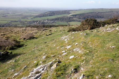
The way ahead now descends before a short ascent takes you to the top of Compton Hill and shortly after a junction of paths (grid ref.ST389560). The route will eventually descend to the left here but first there is the short climb to the top of Crook Peak which offers a wonderful panorama of the Somerset countryside and the Bristol Channel. Having had a rest and enjoyed the view descend to the junction of paths and descend towards the pretty village of Compton Bishop.
The path descends steadily and you need to look out for the exit from the path into Compton Bishop at grid ref. ST395551). Turn left here down into the village. You may wish to explore the village but to continue turn right at the T-junction with a road. Take the first lane on your left and walk to the next road junction. Almost opposite is a footpath that leads slightly uphill to reach a footpath junction (grid ref ST400554). Turn right here and follow the path to Bourton Farm (grid ref ST410551). Turn right down the farm access track and almost immediately take the footpath on your left. This path leads in woodland, bears right around the edge of an old quarry and brings you out on the road in the village of Cross, which has two pubs. Turn left along the road and nearing the A38 turn left onto a signed bridleway (grid ref. ST418547). Follow this bridleway uphill back to the start.
Other walks nearby
| Walk 3666 | West Mendip Way & Old Ditch from Rodney Stoke | moderate | 7.0 miles |
| Walk 2097 | Blagdon Lake | easy/mod | 5.7 miles |
| Walk 2172 | Ebbor Gorge & Priddy from Wookey Hole | easy/mod | 6.3 miles |
| Walk 2184 | Ebbor Gorge from Wookey Hole | easy/mod | 3.0 miles |
| Walk 2201 | Historic Wells Circular | easy | 1.5 miles |
| Walk 1275 | Wells, North Wootton & Worminster | moderate | 9.5 miles |
| Walk 1346 | Priddy, Ebbor Gorge & Wookey Hole from Wells | moderate | 13.5 miles |
| Walk 3332 | Cameley & Hinton Blewett from Litton | easy | 5.6 miles |
| Walk 2426 | Wraxall circular from Tyntesfield | easy | 3.2 miles |
| Walk 1973 | River Parrett from Pawlett | easy/mod | 7.1 miles |
Recommended Books & eBooks
No suggestions for this area.Messaging & Social Media
Message Walking Britain and follow the latest news.

Mountain Weather
Stay safe on the mountains with detailed weather forecasts - for iOS devices or for Android devices.