Walk 1874 - printer friendly version
The River Usk from Bettws Newydd Walk
Author - Lou Johnson
Length - 6.5 miles / 10.6 km
Ascent - 600 feet / 182 metres
Grade - easy/mod
Start - OS grid reference SO361061
Lat 51.7499340 + Long -2.9270356
Postcode NP15 1EQ (approx. location only)
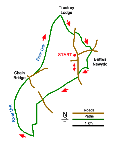
A pleasant circular walk from the village of Bettws Newydd in Monmouthshire uses field paths to descend to the fine church at Kemeys Commander. From here the route continues to the River Usk. The river is then followed upstream for four kilometres. Heading back to the start a short ascent offers excellent view to Ysgyryd Fawr and the Sugarloaf.
The start if the Black Bear Inn in Bettws Newydd (grid ref. SO361061). After walk south through the village. After 600 metres turn right onto a signed path just before a large house (grid ref. SO361056). Follow the path in a south-westerly direction across the golf course to reach the B4598 at a stile (grid ref. SO350049).
Cross the road and take the lane opposite (Church Street) and continue into Kemeys Commander. Pass the small church on the left and follow the lane as it bends left. Reaching a large farm, bear right along the lane beside the Dutch barn. Follow this lane to reach the north bank of the River Usk.
Turn right along the riverside path for two kilometres to reach the B498 and the Chain Bridge. Cross the road and take the lane opposite (signed to Bettws Newydd). After 300 metres turn left over a stile by fingerpost and regain the riverside path. Continue for a further two kilometres. After a kilometre, the path leaves the river and continue past Brynderwen Farm on your right. Continue for 300 metres past Brynderwen to reach a footpath on the right (grid ref. SO356074). Follow this path southeast to join the access drive for Brynderwen. Follow the drive to a road (grid ref. SO360068).
Turn left and after a few metres turn right onto a signed path at a metal gate. On this section of the walk there are fine views to the Sugarloaf and Ysgyryd Fawr. Reaching a lane, turn left to a T-junction. Go straight ahead to join a signed path descending across fields to reach the Church of St. Aeddan. Exit the churchyard to the south-west and follow the grassy path to exit onto a lane. Turn right back to the start.
Messaging & Social Media
Message Walking Britain and follow the latest news.

Mountain Weather
Stay safe on the mountains with detailed weather forecasts - for iOS devices or for Android devices.