Walk 1949 - printer friendly version
Nottingham Hill Walk
Author - Lou Johnson
Length - 4.5 miles / 7.3 km
Ascent - 700 feet / 212 metres
Grade - easy/mod
Start - OS grid reference SO989272
Lat 51.9432990 + Long -2.0174108
Postcode GL52 3PP (approx. location only)
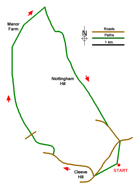
This circular walk starts from the western flank of Cleeve Hill, the highest summit in the Cotswolds, and continues west to explore Nottingham Hill and the surrounding countryside. The route follows paths and quiet lanes to gain the summit from where excellent views can be enjoyed. Nottingham Hill is also the site of a hillfort and there is still evidence of the extensive ramparts.
The start is Cleeve Hill car park (grid ref. SO989272) which lies on the south side of the B4632 up a lane leading to Cleeve Hill Golf Club. The public car park lies through a gate beyond the club house. After parking exit the car park and take the broad path with the club house on your immediate right. After 200 metres fork right onto a less-obvious grassy path keeping to the right of a large house. Continue down to a stile and metal gate and the B4632.
Cross the B4632 and join Stockwell Lane opposite. Follow the lane for 800 metres to reach a house on the right ("Roundhouse"). Turn right onto a tarmac drive and take the signed bridleway on the left (grid ref. SO979273). Initially enclosed by hedges the path enters a field where you turn left and follow the left-hand hedge. After 250 metres ignore paths left and right and continue ahead to Bushcombe Lane (grid ref. SO975276). Turn right uphill and take the first signed footpath on the left.
The onward path lies near the foot of Nottingham Hill. The route crosses many fields and paddocks and clear on the ground. After one and a half kilometres of easy walking you reach a fork in the path just after a gate (grid ref. SO972291). Bear right and continue across fields keeping Manor Farm on your left to reach a clear track (grid ref. SO973294). Go straight across the track to entre a field. Walk half right across the field aiming for the far right-hand corner and gate which leads onto an enclosed track (grid ref. SO977298).
Turn right onto the Winchcombe Way. You now have a steady climb of just over 500 feet onto Nottingham Hill. The path soon enters woodland, turns left and then right tom complete the climb. Pass Gotherington Farm on your right and join a lane. Follow the lane ahead and continue down to a lane. Walk ahead to the B4632 and cross with care to join the lane used to access the car park. A short ascent takes you up past the club house and Cleeve Hill car park.
Messaging & Social Media
Message Walking Britain and follow the latest news.

Mountain Weather
Stay safe on the mountains with detailed weather forecasts - for iOS devices or for Android devices.