Walk 2065 - printer friendly version
Waun Fach & Y Grib from Pengenfford Walk
Author - Lou Johnson
Length - 6.5 miles / 10.6 km
Ascent - 1700 feet / 515 metres
Grade - moderate
Start - OS grid reference SO177303
Lat 51.965062 + Long -3.1992877
Postcode LD3 0EW (approx. location only)
This walk onto the Black Mountains of the Brecon Beacons National Park offers superb views across the Wye Valley and some of the mountains to the west including Pen-y-Fan the highest in the national park. The walk is a linear route offering the walker a chance to traverse the fine ridge of Y Grib. Generally the paths are good although some sections can be rather wet underfoot. It is also worth noting that when cloud covers the hills then inexperienced walkers may find navigation problematic.
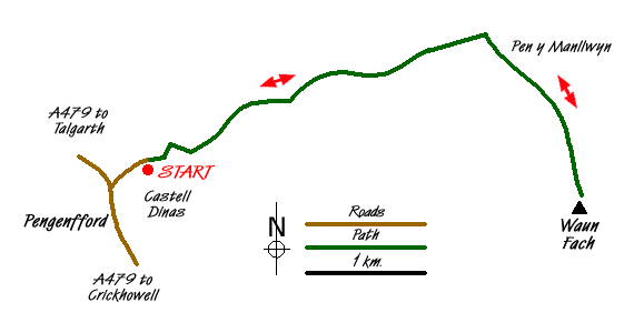
The start is the small parking area (SO177303) on the narrow lane leading to Dinas Farm off the A479 at Pengenfford. Parking is limited and you may have to use the pub car park on the west side of main road where a small change is payable. Assuming you park in the lane, continue along the lane bearing right up a track enclosed by trees. This can be wet and muddy but do not let this deter you! You emerge from this track faced with an excellent view of the Y Grib ridge. There are a number of options on offer but I feel the best is to take the path that traverses the flank of the ridge. This gains height steadily bringing you out onto the ridge proper at the first col on the ridge (grid ref. SO187308).
Once on the ridge a clear path leads ever upwards with improving views as you climb. There are a couple of rocky sections and you soon reach a large cairn where you might take a break to enjoy the beautiful scenery in this part of Wales. Continuing the climb, do not be persuaded to follow one of the paths lower down on the left hand side of the ridge. Instead follow the crest. This will lead you onto a generally clear path across the moor heading ENE to gain the main ridge (grid ref. SO206314) just west of Pen y Manllwyn.
Turn right onto the main path and continue across the moor towards Waun Fach. Generally the path is good and the wet sections can generally be avoided by using the usual strategies of total avoidance or a fast direct attack. As you near the mound of Waun Fach there is a particularly wet section and this is best avoided by taking an avoiding line well to the left across the rough pathless moor. The summit of Waun Fach offers very little and the summit is rather an anti-climax. The remains of the concrete base of a trig point indicate what might have been the highest point, which is hard to determine. However the views enjoyed getting here are ample reward.
The return route follows the outward route although you may wish to continue the full length of the ridge perhaps adding a visit to the Castell Dinas hill fort as extra interest. This was not the case when this walk was researched as we had rushed down the Y Grib ridge trying to avoid the heavy shower that we had watched approach for well over half an hour. Despite the rush we still managed to get soaked!
Messaging & Social Media
Message Walking Britain and follow the latest news.

Mountain Weather
Stay safe on the mountains with detailed weather forecasts - for iOS devices or for Android devices.