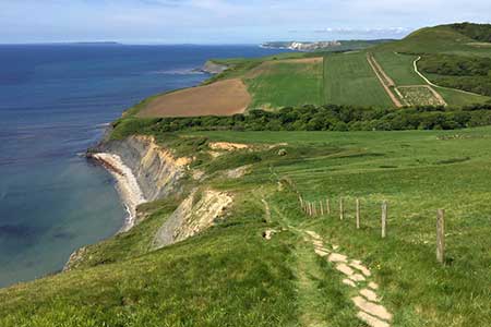
Houns-tout Cliff from Kingston
Dorset Walk
County/Area - Dorset
Author - Lou Johnson
Length - 3.5 miles / 5.7 km Ascent - 450 feet / 136 metres
Time - 2 hours 10 minutes Grade - easy
Maps 

| Ordnance Survey Explorer OL15 | Sheet Map | 1:25k | BUY |
| Anquet OS Explorer OL15 | Digital Map | 1:25k | BUY |
Walk Route Description
Click image to see photo description.
A Dorset walk from Kingston that explores the area to the south of the village including rolling downs and a short section of the coast. The highlight of the walk is Houns-tout Cliff which rises nearly 500 feet above the sea and provides superb views along the coast in both directions.
The start is the small car park lying 300 metres west of Kingston (grid ref. SY954795). After parking return down the lane into the village with its attractive stone built cottages. Pass the church and take the next lane on the right (South Street). The lane climbs out of the village to pass through woodland before emerging onto open downs. Leaving the trees, the lane descends towards the coast. Where the lane turns right, continue ahead over a stile. The onward path takes you into a valley soon reaching the South West Coast Path (grid ref. SY954775).
Turn right along the coast path and climb steeply up to the top of Houns-tout Cliff. The view is superb and includes a long section of the Jurassic Coast especially to the west. After enjoying the view continue to a stile close to a stone seat (grid ref. SY950773). Turn right over the stile towards Kingston. Initially the path crosses farmland along the edge of the escarpment. As you near Kingston the path enters pleasant woodland (The Plantation) to reach Houns-tout car park where the walk began.
Other walks nearby
| Walk 1331 | Kimmeridge & Tyneham | easy/mod | 6.8 miles |
| Walk 1534 | Swyre Head & Tyneham Cap from Kimmeridge | moderate | 11.8 miles |
| Walk 1995 | Houns-tout & Swyre Head from Kimmeridge | moderate | 8.7 miles |
| Walk 2925 | St Aldhelm's Head near Worth Matravers | easy | 4.1 miles |
| Walk 3286 | Dancing Ledge & Durlston Head from Langton Matravers | easy/mod | 7.0 miles |
| Walk 2568 | Egmont Point & Kimmeridge Bay from Tyneham | moderate | 14.0 miles |
| Walk 1533 | Gad Cliff, Povington Hill & Tyneham | easy/mod | 4.5 miles |
| Walk 2579 | Purbeck Coast from Swanage | moderate | 10.0 miles |
| Walk 1634 | Old Harry & Ballard Down from Studland | easy/mod | 5.3 miles |
| Walk 3396 | Agglestone & Old Harry Rocks | easy/mod | 6.4 miles |
Recommended Books & eBooks
Walking the Jurassic Coast
 This guidebook includes 30 walks on the Jurassic Coast of Devon and Dorset. Covering the coast between Exmouth and Bournemouth, these delightful routes range from 3 to 16 miles (5 to 24km), exploring and explaining the spectacular geology of this World Heritage area with clear, easily understood descriptions, cross-sections and timelines.
More information
Messaging & Social Media
Message Walking Britain and follow the latest news.

Mountain Weather
Stay safe on the mountains with detailed weather forecasts - for iOS devices or for Android devices.