Deepdale Circular (near Dent)
Yorkshire Dales Walk
Nat Park - Yorkshire Dales - Three Peaks Country
County/Area - Cumbria
Author - Lou Johnson
Length - 7.0 miles / 11.4 km Ascent - 1200 feet / 364 metres
Time - 4 hours 40 minutes Grade - moderate
Maps 

| Ordnance Survey Explorer OL2 | Sheet Map | 1:25k | BUY |
| Anquet OS Explorer OL2 | Digital Map | 1:25k | BUY |
Walk Route Description
Click image to see photo description.
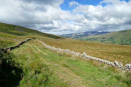
This walk explores Deepdale which lies south of Dentdale between Wnernside and Great Coum. The route follows paths and tracks up the dale to nearly reach the head of the dale. A short section of road walking leads to Occupation Lane which contours the eastern flank of Great Coum before dropping down into the valley to return to the start. Throughout the walk there are excellent views of Deepdale, Dentdale and the surrounding hills.
The start is Mill Bridge which lies a few miles south-east of Dent (grid ref. SD721860) where limited parking is available. Parking can also be obtained further along the lane. After parking, follow the lane south-east. At the next junction keep right and continue up Dyke Hall Lane. After a kilometre of easy uphill walking the lane bends left (grid ref. SD726849). Take the signed path on the right. The path sees few walkers but heads up the valley over stiles to reach Mire Garth. It is useful to have the relevant OS 1:25000 map to help with navigation.
Beyond Mire Garth, the path continues across fields to reach Deepdale Head Farm (grid ref. SD726833). Maintain direction up the valley with the path becoming less obvious as the ground steepens. After a steep section over grass the path exits onto a lane (grid ref. SD724826). Cross the stile and bear left uphill. After 300 metres up the road, turn right onto a clear track (Occupation Road). After an initial ascent the track levels before starting a gradual descent across the side of Great Coum. After 4.3 km. from the road, you reach a junction (grid ref. SD711846).
Turn right and descend more steeply down Nun House Outrake (track) to reach the valley road at Peacock Hill Farm. Cross the road and take the signed footpath opposite, which drops down to farm buildings at Scow (grid ref. SD722855). Just past the buildings the path heads left, crosses a number of fields and reaches a path junction (grid ref. SD720859). Turn right and continue back to the start at Mill Bridge.
Other walks nearby
| Walk 3135 | Dentdale & Bleamoor | moderate | 12.5 miles |
| Walk 1052 | Whernside & Dentdale | mod/hard | 12.0 miles |
| Walk 3233 | Dent & Gawthrop | easy/mod | 6.0 miles |
| Walk 1970 | Great Knoutberry Hill & Dent Head | moderate | 9.5 miles |
| Walk 3032 | Gragareth & Great Coum from Yordas Cave | moderate | 9.0 miles |
| Walk 1184 | Whernside & Scales Moor | moderate | 11.0 miles |
| Walk 3340 | Blea Moor & Denthead from Ribblehead | moderate | 8.2 miles |
| Walk 1208 | Ingleborough & Park Fell | moderate | 7.5 miles |
| Walk 3500 | Ingleborough (northern approach) | moderate | 9.5 miles |
| Walk 2438 | Cautley Spout & the Calf from Sedbergh | moderate | 10.0 miles |
Recommended Books & eBooks
Walking the Lake District Fells - Mardale and the Far East
 Part of the Walking the Lake District Fells series, this guidebook covers a wide range of routes to 36 Lakeland summits that can be climbed from the Ullswater, Haweswater, Troutbeck, Kentmere and Longsleddale valleys, with highlights including High Street, Place Fell and the Kentmere fells. Suggestions for longer ridge routes are also included.
More information
Walking the Lake District Fells - Wasdale
 Part of the Walking the Lake District Fells series, this guidebook covers a wide range of routes to 25 Lakeland summits that can be climbed from the Wasdale, Eskdale and Ennerdale valleys, with highlights including Scafell Pike, Great Gable and Pillar. Suggestions for longer ridge routes are also included.
More information
Messaging & Social Media
Message Walking Britain and follow the latest news.

Mountain Weather
Stay safe on the mountains with detailed weather forecasts - for iOS devices or for Android devices.