Overton & the Harroway
Hampshire Walk
County/Area - Hampshire
Author - Lou Johnson
Length - 4.3 miles / 7 km Ascent - 350 feet / 106 metres
Time - 2 hours 30 minutes Grade - easy
Maps 

| Ordnance Survey Explorer 144 | Sheet Map | 1:25k | BUY |
| Anquet OS Explorer 144 | Digital Map | 1:25k | BUY |
Walk Route Description
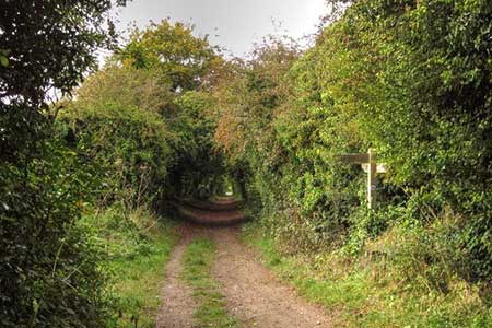
Click image to see photo description.
A short Hampshire walk from Overton Railway station. The route explores green lanes including the ancient Harroway which dates back some 7000 years. The green lanes are fringed with a mixture of trees and cross the rolling countryside of the Hampshire Downs.
The start is Overton Railway Station (grid ref. SU518508). There is pay and display parking available. After parking, enter the station and use the footbridge to cross the railway. Then take the footpath towards Overton Mill. Reaching the road, turn left and pass between the main works on your left and the car park on your right to join a green lane which runs between hedges onto the downs. Reaching a T-junction of tracks, turn left and continue along the Harroway to the B3051 (grid ref. SU514517).
Bear right along the road for a few metres and cross to a track opposite, re-joining the Harroway. Continue west along this ancient route. After 500 metres, Ignore the footpath on the left and a bridleway on the right. At the next cross track (Court Drove) reached after 400 metres, continue ahead. 600 metres beyond Court Drove turn left at a marker post with yellow waymark (grid ref. SU501511). Follow the path downhill with a hedge on your left. Go straight over a cross track and follow the onward path with a hedge on your right.
Pass through a strip of woodland and continue to cross the railway (take care as trains approach fast). Maintain direction beside Lordsfield Plantation ( on your left) to join an access track for the sewage works. Continue along the track to a lane (grid ref SU506498). Turn left and continue along the lane for 700 metres to a T-junction. Turn left up Court Drove and to the entrance/exit for the primary school on your left. Take the footpath opposite (right) through a metal kissing gate. The path follows the right-hand edge of a field to exit through another kissing gate onto the B3051.
Turn left and almost immediately right onto a clear path. Follow the path as it loops round past former milling ponds to join Station Road. Turn left and walk along the grass verge and turn left up the next road on the left (Station Approach). Continue uphill back to Overton railway station.
Other walks nearby
| Walk 3413 | North Wessex Downs & Source of the Test | moderate | 15.0 miles |
| Walk 1508 | Hannington & Kingsclere circular | easy | 6.0 miles |
| Walk 2063 | Watership Down and Ladle Hill from the Sydmonton Estate | easy | 4.5 miles |
| Walk 3594 | Beacon Hill near Burghclere | easy | 1.5 miles |
| Walk 3595 | Old Burghclere & Burghclere from Beacon Hill | easy/mod | 5.6 miles |
| Walk 1025 | Farleigh Wallop and Ellisfield | easy/mod | 6.5 miles |
| Walk 2114 | Hampshire and Berkshire Heights | moderate | 15.0 miles |
| Walk 1847 | Silchester Common & Calleva Atrebatum | easy/mod | 6.2 miles |
| Walk 2459 | Upper Wield & Godsfield Circular | easy/mod | 6.7 miles |
| Walk 1128 | Bradley & Burkham Circular | easy | 5.5 miles |
Recommended Books & eBooks
Walking Hampshire's Test Way
 Guidebook to walking the 71km (44 mile) Test Way in Hampshire from high on the chalk downs of Inkpen Beacon to the Eling Tide Mill near Southampton Water. Following the beautiful, crystal clear River Test, it passes picturesque villages and fascinating historic sites. Also includes 15 day walks to explore this lovely part of pastoral England.
More information
Messaging & Social Media
Message Walking Britain and follow the latest news.

Mountain Weather
Stay safe on the mountains with detailed weather forecasts - for iOS devices or for Android devices.