Walk 2168 - printer friendly version
The Slaughters Walk
Author - Lou Johnson
Length - 8.6 miles / 14 km
Ascent - 800 feet / 242 metres
Grade - easy/mod
Start - OS grid reference SP119235
Lat 51.9099100 + Long -1.8284175
Postcode GL54 3AD (approx. location only)
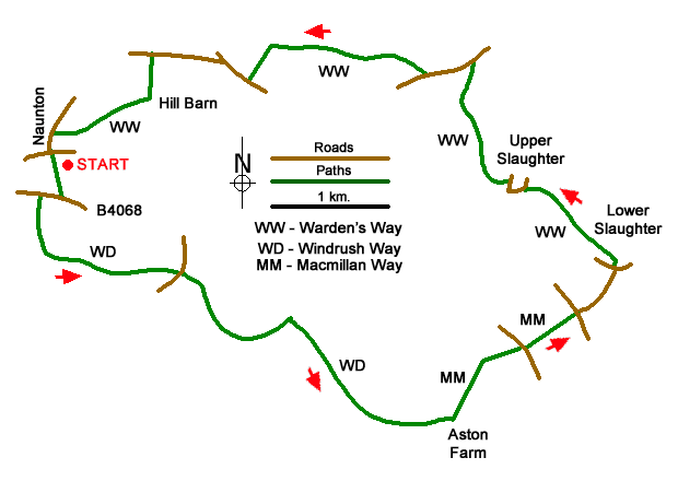
Starting from Naunton this Cotswolds walk explores the Windrush Valley, visits the attractive villages of Lower and Upper Slaughter with the buildings constructed from honey coloured stone. Both of the Slaughters are worth exploring with the splendid manor house and parish church in Upper Slaughter of note. The focus of attention Lower Slaughter is the River Eye which adds to the cram of the village. The route follows sections of three long distance footpaths - Windrush Way, Macmillan Way and the Warden's Way, which are waymarked.
The start is Naunton where limited on-street parking is available by the Black Horse Inn (grid ref. SP119235). Facing the Black Horse Inn, turn left and take the first driveway on the left. Continue along the drive, cross the River Windrush and follow a walled track up to the B4068 (grid ref. SP119231). Turn right and after 150 metres turn left by the fingerpost. Continue ahead along a track soon walking past a plantation on your left. At the end of the plantation pass through a gate (grid ref. SP118271) and bear half-left along a grassy path to cross a small footbridge. Once across the bridge turn left and follow a clear grassy path for about a kilometre to reach a lane. Turn left and take the next footpath on the right (signed Windrush Way).
Follow the undulating path which climbs above the river on two occasions to reach a bridge over the Windrush after three kilometres. Cross the bridge and turn left onto the Macmillan Way leaving the Windrush Way (grid ref. SP151213). Follow the path for 600 metres and turn half right to cross a field to a road (grid ref. SP157219). Cross the road and take the path opposite (Signed Gloucestershire Way) to reach a T-junction. Take the lane ahead and continue to a T-junction in Lower Slaughter. Cross the stone bridge (slightly to the left) over the River Eye and turn left in front of the cottages. Continue along a narrow section of path to exit onto a road. Take the first lane on the left to join Warden's Way.
The well-used path leads to a road in Upper Slaughter. Turn left and follow the road as it bends right. At the next junction (with an island in the road) keep right and keep right again continuing along the road past a phone box and turn left along a wide path with the church above on the left. You are now on the Warden's Way. The path follows the River Eye up a valley eventually passing through woodland to reach the B4068. Turn left and after 350 metres turn right on the signed continuation of the Warden's Way (grid ref. SP1482410). Immediately after leaving the road fork left and ignore the bridleway on the right. A steady climb leads across fields to a barn. Turn left here and continue to a road. Turn right and at the next junction fork left. Continue for 600 metres past Brockhill Farm and turn left along the signed bridleway. Descend to Hill Barn and then head half right over fields to reach a road in Naunton. Turn left downhill back to the start.
Messaging & Social Media
Message Walking Britain and follow the latest news.

Mountain Weather
Stay safe on the mountains with detailed weather forecasts - for iOS devices or for Android devices.