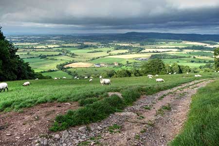
Merbach Hill from Dorstone
Herefordshire Walk
County/Area - Herefordshire
Author - Lou Johnson
Length - 6.5 miles / 10.6 km Ascent - 1000 feet / 303 metres
Time - 4 hours 20 minutes Grade - easy/mod
Maps 

| Ordnance Survey Explorer 201 | Sheet Map | 1:25k | BUY |
| Anquet OS Explorer 201 | Digital Map | 1:25k | BUY |
Walk Route Description
Click image to see photo description.
This Herefordshire walk from Dorstone explores the hilly landscape on the south side of the Wye Valley. The first objective is Merbach Hill (318 m) from where there are views north to the River Wye as it meanders down a broad valley. The route then turns east towards Bredwardine before striking south to pass Arthur's Stone, an ancient burial chamber, to return to Dorstone.
Limited on street parking is available near the village green in Dorstone (grid ref. SO313417). There is also a small car park a short distance southeast from the village green. After parking turn north from the village green and follow Church Road past the phone box to enter the churchyard. Keep to the right of the church (worth visiting if you have time) and exit onto the B4348. Turn left and take the first footpath on the right by a fingerpost. Pass through the kissing gate and initially follow the path shortly crossing the River Dore and the old railway line. Cross the next field half left, go straight across a byway (Spoon Lane) and continue in the same direction across another field to reach a clear access drive (grid ref.SO314426).
Bear left along the track, to reach Llan Farm. Follow the waymarked route around the farm to join a track which is followed towards Scar Lane. When the track bends left continue ahead up to a stile in the hedge. Cross the lane and continue with hedge on your right to a track. Turn left and shortly after right to follow path to Arthur's Stone Lane (grid ref. SO311438). Turn left and continue to where the lane bends right. Continue straight ahead through a metal gate with adjacent finger post and continue to the OS trig column on Merbach Hill (grid ref. SO3144770).
To start the descent walk right through bracken for 140 metres to reach a Wye Valley Walk marker post. Follow the waymarked WVW downhill passing Woolla Farm on your left. After 2.5 kilometres of downhill walking the WVW turns right (grid ref. SO325445) and drops down to a road (Bredwardine Hill). Turn right uphill. At the next junction fork left up the no through road. Follow the lane for 400 metres and then take the signed bridleway on the right.
The route follows the valley floor beside a stream. After 700 metres your reach the rear of a house on your right and an enclosed green lane between hedges. Turn left and join the rising path that veers diagonally up the hillside to a gap in a hedge (grid ref. SO319439). Pass through the gap into a field and keep the hedge on your right and continue up to a junction with the Three Rivers Ride. Continue ahead on the bridleway for 500 metres to reach Arthur's Stone Lane. Continue along the lane to reach Arthur's Stone on your right (grid ref. SO319431). Turn right off the lane as indicated by the fingerpost and descend across pastures to reach the B4348 (grid ref. SO318421).
Bear right along the B4348. Care is needed for 300 metres until the main road bends right. Continue ahead at this point signed to Dorstone. After 300 metres turn right into Chapel Lane and continue back to the village green in Dorstone.
Other walks nearby
| Walk 1957 | Cefn Hill & Vagar Hill - Golden Valley | easy/mod | 5.5 miles |
| Walk 1660 | Craswall Priory & Hay Bluff | easy/mod | 6.0 miles |
| Walk 1238 | Hay Bluff & Twmpa Circular | moderate | 6.0 miles |
| Walk 3204 | Hay Bluff & Twmpa | moderate | 10.3 miles |
| Walk 2935 | Llanthony Priory from Capel-y-ffin | easy/mod | 7.7 miles |
| Walk 3622 | Llanthony Priory from Longtown | mod/hard | 7.0 miles |
| Walk 1237 | Cwmyoy & Hatterrall Hill from Llanthony Priory | moderate | 10.0 miles |
| Walk 3203 | Vale of Ewyas from Llanthony Abbey | moderate | 10.7 miles |
| Walk 3342 | The Hatterall Ridge from Llanthony Priory | very hard | 10.0 miles |
| Walk 3285 | The Hergest Ridge and Huntington from Kington | moderate | 12.0 miles |
Recommended Books & eBooks
No suggestions for this area.Messaging & Social Media
Message Walking Britain and follow the latest news.

Mountain Weather
Stay safe on the mountains with detailed weather forecasts - for iOS devices or for Android devices.