Walk 2185 - printer friendly version
Ben Vorlich from Loch Earn Walk
Author - Rob Kay
Length - 6.0 miles / 9.8 km
Ascent - 2880 feet / 873 metres
Grade - moderate
Start - OS grid reference NN632231
Lat 56.380332 + Long -4.2169885
Postcode FK19 8QE (approx. location only)
This route approaches Ben Vorlich from the north side and offers splendid scenery. At the same time it is a justifiably popular introduction to the higher Scottish peaks. Within an hour or so drive of many larger Scottish cities, the climb is readily accessible on a day trip. At any time of year, and even in poor conditions, the broad ridge leading from Loch Earn is a well-trodden and relatively safe walk suitable for young and old, and on a fine day you may well encounter a dozen or more parties making their way up or down. On the day we made our attempt, 27th May 2007, the Ben even offered some unexpected sport, as the balmy conditions by the loch gave way to mist and a furious blizzard on the tops - a salutary lesson that even in summer, walkers must be prepared for arctic conditions above 700 metres in Scotland.
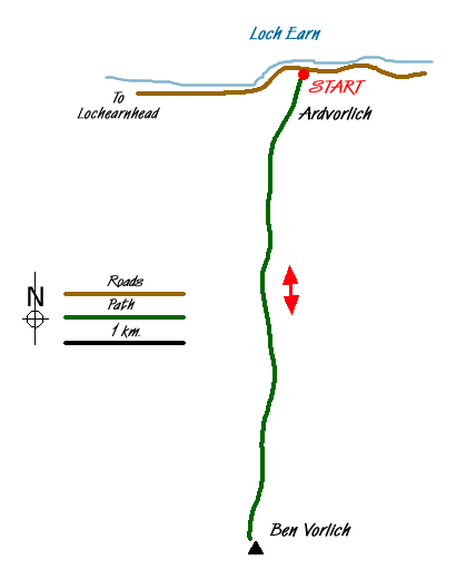
The approach is from the single track road that skirts the southern side of Loch Earn, beloved by fly fishermen for the plump brown trout and rainbows that are at their best in May. There is adequate roadside parking by Loch Earn on most days close to the Ardvorlich estate (Grid ref. NN632231). The path avoids the main route to the house, skirting around it to the east, and is well signposted. A pleasant, and well-made up track gradually ascends through parkland to the tree line, from where the route leaves Glen Vorlich over a fine footbridge that crosses the Coire Buidhe burn and then takes a steep ascent due south up the broad ridge to the summit trig point at 985 metres. A broad and fairly level path leads in a few hundred metres to the eastern summit, just a metre or so lower.
Here, the more adventurous will head across the fairly rugged Bealach an Dubh Chorein for the additional attractions of Stuc a Chroin - 975 metres. There are a couple of possible alternative descent routes back to the car, mainly involving a traverse across rough scree and heathery slopes. Having two young boys with me on this occasion, and with biting snow cutting across and turning the summit into a white-out, we sensibly headed back down the way we had come.
The views towards the north are quite stunning on the descent, with a wide plateau across the Nevis range still well plastered in snowfields until late in the season, and the lovely deep blue of the loch below.
It is an easy Munro, but none the worse for that, and a great, old fashioned kind of day out on the hills that cannot fail to appeal to folk who might baulk at the bigger and sterner challenges visible to the north.
Messaging & Social Media
Message Walking Britain and follow the latest news.

Mountain Weather
Stay safe on the mountains with detailed weather forecasts - for iOS devices or for Android devices.