Walk 2188 - printer friendly version
Great Nodden & Great Links Tor Walk
Author - Lou Johnson
Length - 6.3 miles / 10.2 km
Ascent - 1100 feet / 333 metres
Grade - moderate
Start - OS grid reference SX525853
Lat 50.6486610 + Long -4.0877242
Postcode EX20 4AZ (approx. location only)
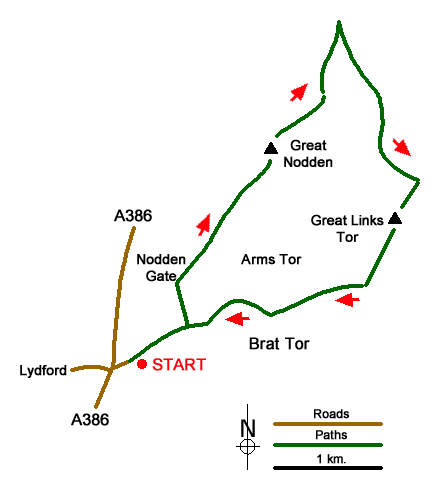
The main objective of this Dartmoor walk is Great Links Tor (586 m.) the fifth highest summit in the National Park. The route also includes a short ascent onto Great Nodden (437 m.) and a section of the Rattlebrook Peat Railway which closed in the early 1930's. The walk follows well-trodden paths and tracks with the view from the summit outstanding.
The walk starts from a car park (grid ref. SX525853) east off the A386 rand reached by a lane from the Dartmoor Inn. Exit the car park and continue up a rising track that is an extension of the lane. Continue until you reach the River Lyd. Do not cross the river and turn left and follow the path alongside a wall north. Where the wall turns left, bear left along the wall for 100 metres and then head right crossing the first track to reach the second track (grid ref. SX532864). Take the higher of the two tracks heading north.
Turn right along the former track bed of the Rattlebrook Peat Railway northwards. As you make progress up the track, Great Nodden can be seen ahead. Leave the old Peat Railway and take the clear path to the summit of Great Nodden. Maintain direction and descend the broad north ridge to regain the old peat railway. You soon reach the reversing point on Coombe Down (grid ref. SX546887), where the wagons changed direction.
Turn back on yourself and take the left fork to continue along the former track bed. The track continues its gradual ascent with the northern slopes of Great Links Tor rising on your right. After just under two kilometres the track bed bends gently left. Just before the bend, take the path your right (grid ref. SX553872) which heads uphill to the summit rocks of Great Links Tor. There is a wonderful granite, an OS trig column and great views. To reach the true summit, rock climbing skills are a required. To descend head south-west down hill on a clear path. At the bottom of the slope turn right along a clear bridleway, which leads to the River Lyd crossing and the car park used at the start.
Messaging & Social Media
Message Walking Britain and follow the latest news.

Mountain Weather
Stay safe on the mountains with detailed weather forecasts - for iOS devices or for Android devices.