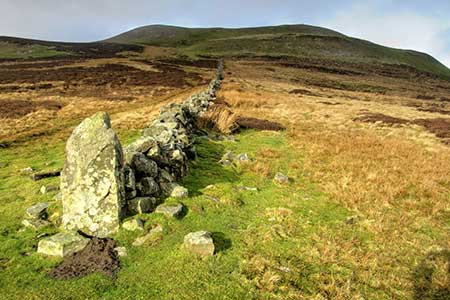
Calver Hill & Reeth Low Moor from Healaugh
Yorkshire Dales Walk
Nat Park - Yorkshire Dales - Swaledale
County/Area - North Yorkshire
Author - Lou Johnson
Length - 6.0 miles / 9.8 km Ascent - 1000 feet / 303 metres
Time - 4 hours 0 minutes Grade - easy/mod
Maps 

| Ordnance Survey Explorer OL30 | Sheet Map | 1:25k | BUY |
| Anquet OS Explorer OL30 | Digital Map | 1:25k | BUY |
Walk Route Description
Click image to see photo description.
Walk from Healaugh in Swaledale explores the moors to the north of the village. The route begins by following Barney Beck upstream before climbing out of the valley and onto the moors. Skirting the western slopes of Calver Hill, the walk continues across Cringley Hill to reach Fore Gill gate. From where the route turns east to road above Arkle Town in Arkengarthdale. After a brief section of road walking the walk crosses Reeth Low Moor across the eastern side of Calver Hill to return to Healaugh.
The start is the centre of Healaugh village (SE017990) where limited parking is available by the notice board beside the B6270. Alternative parking is described in the final paragraph. After parking walk west along the B6270 and turn right before the phone box. Follow the lane and take the first signed footpath on the right. The path leads across fields to join a bridleway (grid ref. SE014990). Turn right along the bridleway. The route soon reaches an isolated house on the right. Continue ahead into trees.
Leaving the trees follow the path with a wall on your left. Continue uphill to pass Nova Scotia (grid ref. SE008996). The onward grassy track soon runs alongside a large walled enclosure on your right. At the end of the enclosure, bear right, cross a track, and maintain direction up to a second walled enclosure. Once past this enclosure, maintain direction across the moor. The path is generally clear on the ground and head roughly northwest to reach the road at Fore Gill Gate (grid ref. NY993009).
Just before the road, turn sharp right along a clear track heading east. Follow the track for about two kilometres across the moor. At grid ref. NZ008013 fork right on to a narrower path which leads to a road. If you miss this path stay on the track which also leads to the road. Turn right along the unfenced road and continue for 700 metres a farm track on the left (grid ref. NZ018012).
The small layby is alternative starting point. To continue turn right on the signed footpath which climbs gently across the moor to reach a path junction (grid ref. NZ015009). Turn left on a path that contours across the hillside. The grassy path bends gently right before turning south across the eastern slopes of Calver Hill. The path climbs gradually reaching an isolated section of wall on your right (grid ref. NZ016000). From here the path descends gently in a southerly direction. Continue to reach a clear track and turn right (grid ref. SE107996). Reaching Thirns, bear left and join a tarmac lane which descends into Healaugh.
Other walks nearby
| Walk 1252 | Great Pinseat | easy/mod | 5.5 miles |
| Walk 1253 | Booze & Slei Gill from Langthwaite | easy | 2.5 miles |
| Walk 3478 | Cringley Hill & Scar House from Langthwaite | easy/mod | 4.8 miles |
| Walk 1056 | Gunnerside & Surrender Bridge | moderate | 10.3 miles |
| Walk 1197 | Gunnerside & Swinner Gills | moderate | 8.5 miles |
| Walk 3093 | Bunton Hush, Blakethwaite & Gunnerside Gill | easy/mod | 5.5 miles |
| Walk 1055 | Penhill & West Burton | moderate | 10.0 miles |
| Walk 3384 | Aysgarth Falls and Caperby | easy | 4.0 miles |
| Walk 1694 | Nappa Hall & Whitfield Gill Force | easy/mod | 6.0 miles |
| Walk 2822 | Aysgarth & Castle Bolton | mod/hard | 14.5 miles |
Recommended Books & eBooks
Trail and Fell Running in the Yorkshire Dales
 Guidebook to 40 of the best trail and fell runs in the Yorkshire Dales National Park. Ranging from 5 to 24 miles, the graded runs start from bases such as Ribblehead, Dent, Sedbergh, Malham and Grassington and take in the region's diverse delights, from castles and waterfalls to iconic mountains such as Whernside, Ingleborough and Pen Y Ghent.
More information
Walking in the Yorkshire Dales: North and East
 This guidebook contains 43 circular day walks in the north and east Yorkshire Dales. It explores the dales, hills and moors between Kirkby Stephen and Pateley Bridge. Walking ranges from gentle 3 mile strolls to more strenuous day-long rambles across the Howgills, Wensleydale, Swaledale, Nidderdale, Mallerstang and Coverdale.
More information
Messaging & Social Media
Message Walking Britain and follow the latest news.

Mountain Weather
Stay safe on the mountains with detailed weather forecasts - for iOS devices or for Android devices.