Somerleyton & Herringfleet Hills Walk
Walk 2237 - Route Maps
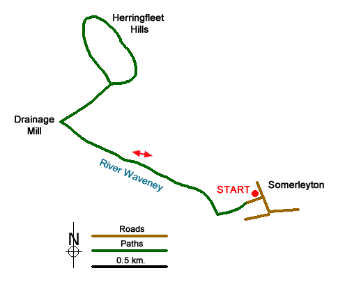
Route Map
Digital Maps - Copyright © 2011-2024. All rights reserved.
Sketch Map
Suggested Maps 

| Ordnance Survey Explorer OL40 | Sheet Map | 1:25k | BUY |
| Anquet OS Explorer OL40 | Digital Map | 1:25k | BUY |
| Ordnance Survey Landranger 134 | Sheet Map | 1:50k | BUY |
| Anquet OS Landranger 134 | Digital Map | 1:50k | BUY |
It is recommended you take a map. The preferred scale is 1:25k.
Start Point Details
Ordnance Survey Grid Ref TM478971
Latitude 52.515402 Longitude 1.650773
Postcode NR32 5QX
what3words start downward.visa.treatable
Walk description may contain detailed information on the start point for this walk.
Further Information
The Broads
Walking in the Norfolk and Suffolk Broads offers a unique mosaic of rivers and shallow lakes, marshes, fens and woodland. This unique habitat is home to some of the rarest plants and creatures in the UK. The Broads is also one of Europe's most popular inland waterways. Once an essential transport network the waterways have evolved for recreational use. Besides the blend of wildlife and distinctive landscapes, man has made his mark with distinctive buildings including some fine windmills. The Broads Walking Guide
Suffolk
The County of Suffolk is in the East of England. Much of the county is low lying although there are a few hills, especially in the west. Arable land predominates and contrasts with the watery landscape of The Broads in the north. A notable feature are the wide estuaries that offer a habitat for a variety of birds. The Suffolk Coast and Heaths is the only National Landscape (formerly AONB) in the county. The highest point is Great Wood Hill, near the village of Rede, which reaches 128 metres (420 ft).
Walk grading - Learn how each walk is assessed and select a walk to suit your ability and experience by going to Walk Grading Details.
Messaging & Social Media
Message Walking Britain and follow the latest news.

Mountain Weather
Stay safe on the mountains with detailed weather forecasts - for iOS devices or for Android devices.