Walk 2259 - printer friendly version
Ilam Walk
Author - Lou Johnson
Length - 4.5 miles / 7.3 km
Ascent - 700 feet / 212 metres
Grade - easy
Start - OS grid reference SK136497
Lat 53.0443970 + Long -1.7985971
Postcode DE6 2BS (approx. location only)
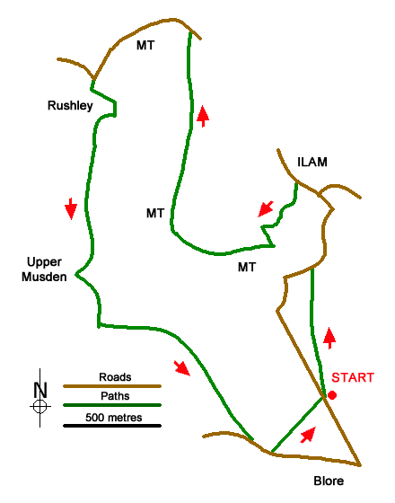
A great walk exploring the village of Ilam, the Manifold Valley, and surrounding countryside. The route passes through Ilam where you can explore before continuing with the walk. A lovely section following the Manifold upstream leads to Rushley. From here the route crosses pastures before climbing up to cross the shoulder of Hazelton Clump before returning to the start.
The walk starts from the Blore Pastures car park (grid ref. SK136497). After parking walk to the end of the car park and continue through the picnic area. The path briefly passes through trees before exiting onto open grassland. Follow the path to reach a lane. Turn right and follow the lane with a fine view of shapely Bunster Hill ahead. Continue along the lane to cross the River Manifold into the village. Keep to the left-hand pavement, pass a phone box and where the road bends right, continue ahead towards Dovedale House. Take the next signed path on the right at a fingerpost and kissing gate (grid ref. SK134509).
You are now on the Manifold Way. Follow the path to pass the Church of the Holy Cross (on your left). Just past the church, turn left and continue to the river. Do not cross the bridge and turn right. The path follows the river for two kilometres passing Hamps Springs where underground water returns to the surface. After dry weather, the river beyond this point may be dry. Stay on the path and exit onto Lodge Lane (grid ref. SK129518). Turn left and continue across Rushley Bridge over the Manifold. Cross a cattle grid and continue to Rushley.
Where the lane turns left, continue ahead. The lane bends left and then right to pass Musden Grange Farm on your right. Just past the farm, bear left off the track and follow a path with a wall on your immediate left. Ignore the path on the right and continue ahead on a rising path through a gap in a hedge. The path heads up the field to a gate. The path continues with a wall on your right before swinging right to reach the ruin of Upper Musden (grid ref. SK123504). Just before the ruins, turn sharp left along a clear track. This is followed around Hazelton Clump (on your right) to Ilam Moor Lane. Turn left and at the first finger post on the left, cross a stile into a field. Continue down the field to another stile with the car park opposite.
Messaging & Social Media
Message Walking Britain and follow the latest news.

Mountain Weather
Stay safe on the mountains with detailed weather forecasts - for iOS devices or for Android devices.