Walk 2271 - printer friendly version
Black Combe from near Stoneside Hill Walk
Author - Lou Johnson
Length - 6.3 miles / 10.2 km
Ascent - 1350 feet / 409 metres
Grade - easy/mod
Start - OS grid reference SD150896
Lat 54.2949200 + Long -3.3074770
Postcode LA18 5LB (approx. location only)
Walk to the summit of Black Combe which lies in the south-western corner of the Lake District National Park within a few miles of the Irish Sea. Rising to 600 metres (1970 feet) the western slopes are rounded and smooth whilst the to the east a series of crags provide scenic interest. The route detailed below uses an approach from the north, which involves less ascent than other routes.
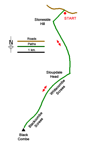
The start is a small off-road parking area (grid ref.SD150896) near the summit of the fell road from Waberthwaite. After parking walk south following a path with a fence on your right to the rocky summit of Stoneside Hill. From here the smooth rounded shape of Black Combe is in view to the south. Descend the other side towards a group of trees and a sheep fold. Cross the fence down in a shallow valley. You will need to pick your route carefully to avoid wet feet.
Head up the easy slope ahead keeping a fence on your left to reach a fence on the almost flat top of Stoupdale Head. Cross the fence and descend slightly to walk along the edge of Whitecombe Screes on your left. Continue along the top of Anna Crag soon arriving at Blackcombe Screes with a deep bowl cut into the hillside. A final steady ascent leads to the summit of Black Combe with its OS trig column. The view from the summit is not the best and it is recommended that you head south to the subsidiary summit (587 m.) from the where the view is much improved.
To return to the start follow the outward route. A short diversion to the right from Stoupdale Head offers an excellent view down Stoupdale. Return to the fence and continue the walk downhill and back to the start.
Messaging & Social Media
Message Walking Britain and follow the latest news.

Mountain Weather
Stay safe on the mountains with detailed weather forecasts - for iOS devices or for Android devices.