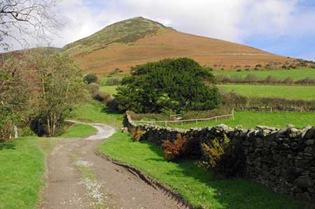
White Combe FROM near Whicham
Lake District Walk
Nat Park - Lake District - Lake District Lesser Fells
County/Area - Cumbria
Author - Lou Johnson
Length - 4.5 miles / 7.3 km Ascent - 1400 feet / 424 metres
Time - 3 hours 40 minutes Grade - easy/mod
Maps 

| Ordnance Survey Explorer OL6 | Sheet Map | 1:25k | BUY |
| Anquet OS Explorer OL6 | Digital Map | 1:25k | BUY |
Walk Route Description
Click image to see photo description.
A short but energetic walk exploring White Combe and its associated valleys. White Combe offers good walking and lies at the southwestern corner of the Lake District National Park. The hill sees few walkers despite offering some fine views to its higher neighbour Black Combe and to Duddon Sands and the Irish Sea.
The start is a small layby 100 metres east of Fox and Goose Cottages on the busy A595 east of Whicham (grid ref. SD158849). After walk in front of the cottages and take the signed foot path into a field. The path runs parallel with the A595 following a hedge on the left. Continue to the end of the field and turn left along a track enclosed by hedges. This leads to the intake wall and open fell. Take the clear path heading roughly cutting across the steep hillside at an angle. A steady climb with the crags of White Hall Knott above on your left. The path bears left and crosses the eastern flank of White Combe.
Leave the path when level with the top of a gulley on the right (grid ref. SD157862) and bear half left up to a large cairn, from the where you can enjoy the best views. From the cairn walk uphill in a northerly direction to re-join the main path and continue up to Whitecombe Head (grid ref. SD151874). A short diversion to the right offers a good view down Stoupdale and the crags at the head of the valley.
From Whitecombe Head, walk west on a grassy path and bear left down into a valley with Whitecombe Screes up to your right. The path descends into the valley turning right and then left to follow Whitecombe Beck downstream. Cross the beck over a small footbridge (grid ref. SD149862) to follow a clear track that leads down to pass Whicham Mill. Stay on the track to reach the A595. Cross with care and turn left. Just past an entrance to Beckside Farm, pass through a gate to follow an unsigned footpath into a field. Aim for the gap in the hedge and continue to the left of a small quarry soon joining a clearer track that leads to the A595.Turn right and the layby is a short distance along the road on the left.
Other walks nearby
| Walk 2271 | Black Combe from near Stoneside Hill | easy/mod | 6.3 miles |
| Walk 3656 | Hodbarrow Lagoon from Haverigg | easy | 4.2 miles |
| Walk 1301 | Great Stickle & Stickle Pike | moderate | 5.0 miles |
| Walk 1993 | Ravenglass & the Esk Estuary | easy | 3.4 miles |
| Walk 1124 | Beacon Tarn & The Beacon from near Torver | easy/mod | 4.0 miles |
| Walk 1058 | Beacon Fell & Beacon Tarn Circular | easy/mod | 4.0 miles |
| Walk 1668 | Silver Knott & Muncaster Fell from Irton Road | easy/mod | 5.0 miles |
| Walk 2355 | Blea Tarn & Eskdale Green | easy/mod | 6.5 miles |
| Walk 3110 | The Old Man of Coniston & Dow Crag from Torver | mod/hard | 8.5 miles |
| Walk 1299 | Green Crag | moderate | 6.5 miles |
Recommended Books & eBooks
Walking the Lake District Fells - Keswick
 Part of the Walking the Lake District Fells series, this guidebook covers a wide range of routes to 30 Lakeland summits that can be climbed from Keswick, Whinlatter, Bassenthwaite, Caldbeck, Mungrisdale and Threlkeld, with highlights including Skiddaw and Blencathra. Includes suggestions for longer ridge routes.
More information
Lake District: High Level and Fell Walks
 This guidebook describes 30 graded fell walks on the ridges and high peaks of the English Lake District, the UK's most popular national park. Reaching some of England's finest and highest mountain scenery, this guide leads readers to classic horseshoes and traditional ascents as well as lesser-known routes to quieter summits.
More information
Messaging & Social Media
Message Walking Britain and follow the latest news.

Mountain Weather
Stay safe on the mountains with detailed weather forecasts - for iOS devices or for Android devices.