Walk 2332 - printer friendly version
Mastilles Lane & Bordley from Kilnsey Walk
Author - Robert Peters
Length - 6.8 miles / 11.1 km
Ascent - 1100 feet / 333 metres
Grade - easy/mod
Start - OS grid reference SD975677
Lat 54.1051790 + Long -2.0397285
Postcode BD23 5PS (approx. location only)
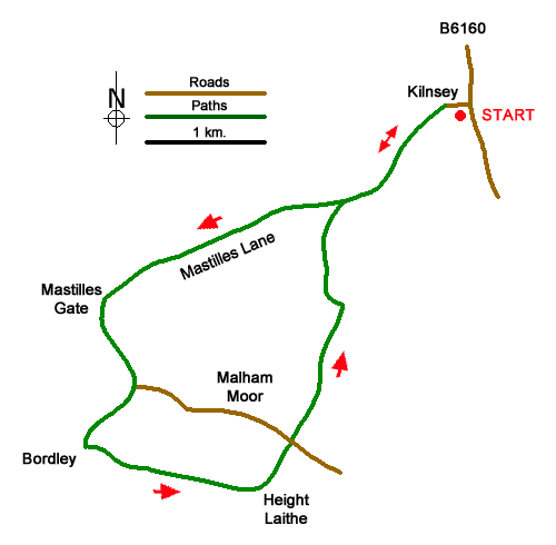
This walk from Kilnsey in Wharfedale explores an area of limestone upland west of the village. The route uses Mastilles Lane to cross Kilnsey Moor and then turns south to the isolated farm of Bordley Green. The walk then continues east across Malham Moor to rejoin Mastilles Lane back to Kilnsey.
The walk starts from Kilnsey Park, where parking is available as well as refreshments (grid ref. SD975677). After parking walk to the B6160 and turn left into Kilnsey village. Take the first lane on the left into the village and keep straight ahead by a small green. You soon reach the end of the tarmac by a gate and cattle grid where you continue ahead up Mastilles Lane. The track is soon enclosed between walls and climbs steadily. Enclosed by walls, this track gains height steadily for three kilometres across Kilnsey Moor. Once over the summit the track descends to Mastilles Gate (grid ref. SD944662).
Go through the gate and turn left following a clear track with a wall. on your left. After 700 metres you reach a cross track (Malham Moor Lane). Go straight across and continue down to Bordley Green Farm. As you approach the farm you reach a wall corner (grid ref. SD943650). Leave the track here and turn left to join a path initially with a wall on your right. Maintain direction across several fields passing a limestone outcrop on the left which is the highest point on Malham Moor. Just after passing a stone barn on the left (grid ref. SD958647), cross the stile and turn left onto a bridle way heading roughly north. Follow the grassy track to reach a gate on Malham Moor Lane (grid ref. SD960650).
Cross the lane and continue along a grassy path which leads generally northwards. Keep to the left of Green Hall Hill soon picking up a clearer track which leads into an enclosed track. Follow this to re-join Mastilles Lane. Turn right and descend back into Kilnsey village.
Messaging & Social Media
Message Walking Britain and follow the latest news.

Mountain Weather
Stay safe on the mountains with detailed weather forecasts - for iOS devices or for Android devices.