Ashdown Forest & Nutley Windmill
East Sussex Walk
County/Area - East Sussex
Author - Lou Johnson
Length - 4.7 miles / 7.6 km Ascent - 550 feet / 167 metres
Time - 2 hours 50 minutes Grade - easy/mod
Maps 

| Ordnance Survey Explorer 135 | Sheet Map | 1:25k | BUY |
| Anquet OS Explorer 135 | Digital Map | 1:25k | BUY |
Walk Route Description
Click image to see photo description.
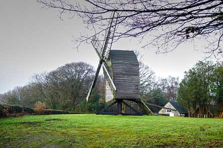
This circular walk explores part of the Ashdown Forest in East Sussex. The route also visits Nutley Windmill, the oldest working windmill in Sussex, Crosses an area of open country interspersed with woodland, and passes the Airman's Memorial which honours six young airmen who lost their lives in the Second World War.
The walk starts from the Friend's Clump car park (grid ref. TQ456289) on a minor road east of the A22 near Nutley. After parking walk towards the clump of trees and turn left along a clear track. After 350 metres fork left and continue to the Nutley Windmill. The mill has open days and is in working condition. After viewing the windmill, retrace you steps back to the track (grid ref. TQ453291) and turn sharp left. After 120 metres fork right off the main track. The track runs beside woodland on your left. Ignore the track on the left and continue beside the woodland. After 400 metres you reach a junction of tracks (grid ref. TQ458293).
Turn left, briefly passing through trees. Keep ahead with trees off to the left and continue for 450 metres to reach a grassy track/path on the right. Take this path and head steadily uphill to Camp Hill Clump (grid ref. TQ469290). There is an OS trig column here (198 m.) which marks the highest point on this walk. Turn right (west) from the trees and follow the broad path that leads to Ellison's Pond. Continue ahead into the car park, turn left, cross the road, and enter Hillies car park. Walk to the back of the parking area and join a clear path heading downhill to the south. After 600 metres you pass the Airman's Memorial with the graves protected by a low stone wall. Continue south to reach a stream at the bottom of the descent (grid ref. TQ458274).
Cross the footbridge on the right and follow the path uphill for 300 metres and turn right up a broad track. This leads back to the car park used at the start which is reached in just over a kilometre.
Other walks nearby
| Walk 1953 | Balcombe & Ardingly Reservoir | easy/mod | 7.8 miles |
| Walk 1048 | Ardingly Reservoir | easy/mod | 8.5 miles |
| Walk 2486 | Plumpton Green & South Downs | easy/mod | 7.7 miles |
| Walk 2427 | Hever & Markbeech from Chiddingstone | easy | 5.9 miles |
| Walk 2479 | Worth Way from Three Bridges, near Crawley | moderate | 14.0 miles |
| Walk 2684 | Falmer to Pyecombe & Blackcap by South Downs Way | moderate | 8.8 miles |
| Walk 2011 | Chartwell from Crockham Hill | easy | 2.8 miles |
| Walk 1633 | Charleston Farm & Firle Beacon | easy/mod | 4.6 miles |
| Walk 1838 | Bateman's & Holton Hill | easy | 5.3 miles |
| Walk 2903 | Stanmer to Streat | moderate | 12.5 miles |
Recommended Books & eBooks
No suggestions for this area.Messaging & Social Media
Message Walking Britain and follow the latest news.

Mountain Weather
Stay safe on the mountains with detailed weather forecasts - for iOS devices or for Android devices.