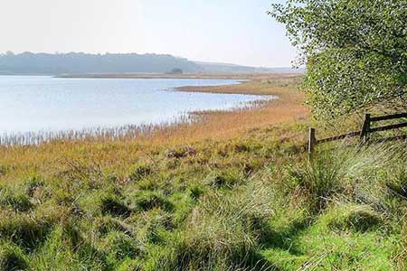
Greenlee Lough and Steel Rigg
Northumberland Walk
Nat Park - Northumberland
County/Area - Northumberland County
Author - Lou Johnson
Length - 7.5 miles / 12.2 km Ascent - 850 feet / 258 metres
Time - 4 hours 40 minutes Grade - easy/mod
Maps 

| Ordnance Survey Explorer OL43 | Sheet Map | 1:25k | BUY |
| Anquet OS Explorer OL43 | Digital Map | 1:25k | BUY |
Walk Route Description
Click image to see photo description.
Starting from Steel Rigg this walk explores a section of Hadrian's Wall and countryside to the north of the wall including picturesque Greenlee Lough. The route follows a quiet country lane before heading across open farmland to pass Greenlee Lough. The walk then joins the Pennine way and heads south to Hadrian's Wall at Hotbank Crags. The undulating path then follows the wall passing Crag Lough, before heading across a line of crags back to the start.
The walk starts from the Steel Rigg car park (grid ref. NY750676) which lies to the north of the B6138. After parking, return to the lane and turn right. Follow the lane for 800 metres to a junction and turn right (signed Gibbs Hill). After a straight section, the lane bends left, then right and then veers left after which turn right onto a signed footpath (grid ref. NY750689). Pass through the kissing gate and cross open country. Eventually the path runs to the left of a plantation before heading left to cross a footbridge over Caw Burn. After a section of boardwalk, the path bears right and runs parallel to the shore of Greenlee Lough - a National Nature Reserve. After a section of plantation on the right you can divert right to the lough for a closer look at this beautiful stretch of water. Return to the main path and turn right.
At a three-way fingerpost (grid ref. NY770701) continue ahead to pass through West Stonefield. Continue along a track, with a wall on your right, to East Stonefield. Climb the ladder stile and continue through the yard and along the track passing the house on your left. Where the track veers left, keep close to the wall on your right and continue to a gate with adjacent ladder stile (grid ref. NY780707). Turn right here to join the Pennine Way. The waymarked path is generally easy to follow and can get wet in places after rain. After a steep pull up to Hadrian's Wall just east of Hotbank Crags, turn right and follow a well-used path along the remains of the wall. The Hadrian's Wall Path has combined with the Pennine Way for the remainder of the walk. Continue across the top of Hotbank Crags, pass above beautifully situated Crag Lough, and continue back to the start at Steel Rigg.
Other walks nearby
| Walk 3404 | Hadrian's Wall - Cawfields to Steel Rigg | easy/mod | 3.5 miles |
| Walk 1677 | Peel Crags & Winshield Crags from Vindolanda | easy/mod | 7.8 miles |
| Walk 2671 | Hotbank Crags & Housesteads from Vindolanda | easy | 5.3 miles |
| Walk 3331 | Cragend & Crow Crags from Housesteads | easy/mod | 8.4 miles |
| Walk 3343 | Hadrian's Wall, Walltown Crags & Aesica | easy/mod | 5.0 miles |
| Walk 2803 | Hadrian's Wall and Haughton Common | hard | 20.0 miles |
| Walk 1786 | Hadrian's Wall & Simonburn circular | easy/mod | 6.8 miles |
| Walk 1987 | Allendale Town Circular | easy/mod | 6.6 miles |
| Walk 1477 | Bellingham to Kiln Rigg by Pennine Way Circular | moderate | 14.3 miles |
| Walk 1478 | Ladyhill to Bellingham circular | moderate | 16.0 miles |
Recommended Books & eBooks
Walking in Northumberland
 This guidebook contains detailed route descriptions for 36 day walks in Northumberland including the Cheviot Hills. The terrain varies from wild walks and craggy ascents to gentle riverside strolls. Each route ranges from 4 to 16 miles in length and there is the opportunity to link several walks together to create longer treks.
More information
Hadrian's Wall Path
 Hadrians Wall Path guidebook to walk the 84 mile National Trail. Described in both directions, the main description is west to east between Bowness-on-Solway and Wallsend, Newcastle, with extensions to Maryport and South Shields. With extensive historical information related to this World Heritage site and separate 1:25,000 OS map booklet included.
More information
Messaging & Social Media
Message Walking Britain and follow the latest news.

Mountain Weather
Stay safe on the mountains with detailed weather forecasts - for iOS devices or for Android devices.