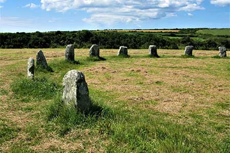
Merry Maidens & Lamorna Cove
Cornwall AONB Walk
Region - Cornwall AONB
County/Area - Cornwall
Author - Lou Johnson
Length - 4.1 miles / 6.7 km Ascent - 550 feet / 167 metres
Time - 2 hours 40 minutes Grade - easy
Maps 

| Ordnance Survey Explorer 102 | Sheet Map | 1:25k | BUY |
| Anquet OS Explorer 102 | Digital Map | 1:25k | BUY |
Walk Route Description
Click image to see photo description.
An interesting walk featuring the Merry Maidens standing stones, Lamorna Cove and a section of rugged coastline following the South West Coast Path. The Merry Maidens are one of the best-preserved stone circles in the British Isles and date from 2500 BC.
The walk starts from the small parking area on the south side of the B3315 that is adjacent to the entrance to the Merry Maidens (grid ref. SW432245). Exit the parking area through a gate to reach the stone circle. After inspecting this fine prehistoric monument, continue across the field to cross a stile. Then walk half left across the next field to a gate by a telegraph pole and exit onto the B3315. Bear right down a signed no-through road. After 400 metres the lane forks. Cork left and follow a bridleway downhill into the Lamorna Valley. Reaching a lane, turn right and follow the lane through Lamorna village. Keep ahead and you will soon pass the Lamorna Wink on your left. The lane then leads you through a beautiful, wooded valley to Lamorna Cove.
Just before the car park, bear right in front of a row of cottages (signed Coast Path to Penberthy). The undulating path initially runs close to the cliff tops on your left. The first landmark is Carn Barges, which is reached after climbing a stepped section of path. This large standing stone is perched above the sea. From here the path turns inland climbing high above the sea. After a short descent through a patchwork of small fields (used for growing flowers) you reach Tater-fu Lighthouse. Beyond the lighthouse the route follows a clear track which forks right inland just after passing a farm up on your right (grid ref. SW436232).
Leave the Coast Path here and follow the track uphill inland. Continue up the track to Tregiffian Farm where you join a tarmac lane. Follow the lane as it bends left and then right. Just after the bend, turn right over a stone stile in the hedge or go through the adjacent gate. Note there is no footpath sign here. Follow the left-hand edge of the field and exit the field by another stile onto a track (grid ref. SW432236). Turn right and continue to Boscawen Rose Farm. Pass between the farmhouse on your right and farm buildings on your left. Just past the farmhouse, turn left and between barns. At the end of the barns veer half left to enter a field. Continue along the right-hand side of this field. Nearing the end of the filed, head half left across the field to a stile in the field corner (grid ref. SW429240).
After crossing the stile continue with hedge on your left. The next field on your left contains a large solitary standing stone, which is aligned with the Merry Maidens. Continue to a sile and into the next field. Head slightly right to another stile in the hedge opposite. Entering the final field, maintain direction across the field to follow the path beside the left-hand hedge. Cross a stile onto the B3315. On your left is the Boskenna Cross. These crosses were used to mark routes across the countryside. Turn right along the road, passing Tregiffian Barrow on your right, and return to the car park by the Merry Maidens. If time permits, cross the road to a stile opposite. The path leads to a massive standing stone called Gun Rith.
Other walks nearby
| Walk 2614 | St Loy's Cove & Logan Rock | moderate | 8.5 miles |
| Walk 1226 | Land's End & Sennen Cove from Porthcurno | moderate | 6.5 miles |
| Walk 2205 | Newlyn - a village trail | easy | 1.0 miles |
| Walk 2298 | Porthgwarra & St Levan Circular | easy | 4.8 miles |
| Walk 3501 | Penzance to Porthcurno via Mousehole and Lamorna | moderate | 11.0 miles |
| Walk 2207 | Penzance - a town stroll | easy | 1.5 miles |
| Walk 1225 | Sennen Cove & Botallack from St Just | moderate | 7.5 miles |
| Walk 3325 | Chun Quoit & Carn Kenidjack | easy | 4.0 miles |
| Walk 1224 | Men-an-tol & Ding Dong Mine | easy | 3.0 miles |
| Walk 1028 | Chun Quoit and Botallack | moderate | 8.0 miles |
Recommended Books & eBooks
South West Coast Path Map Booklet - Minehead to St Ives
 Map of the northern section of the 630 mile (1014km) South West Coast Path National Trail. Covers the trail from Minehead to St Ives along the north Devon and Cornish coastline. This convenient and compact booklet of Ordnance Survey 1:25,000 maps shows the route, providing all of the mapping you need to walk the trail in either direction.
More information
The South West Coast Path
 Guidebook to walking the entire South West Coast Path National Trail. The route runs for 630 miles from Minehead to Poole along the north Devon, Cornish, south Devon and Dorset coastline. Divided into 45 stages, this long-distance coastal trek could be completed within 4 weeks, or walked in sections. Guide includes maps and essential information.
More information
Messaging & Social Media
Message Walking Britain and follow the latest news.

Mountain Weather
Stay safe on the mountains with detailed weather forecasts - for iOS devices or for Android devices.