Highlights of Avebury
Wiltshire Walk
County/Area - Wiltshire
Author - Lou Johnson
Length - 8.8 miles / 14.3 km Ascent - 500 feet / 152 metres
Time - 4 hours 50 minutes Grade - easy/mod
Maps 

| Ordnance Survey Explorer 157 | Sheet Map | 1:25k | BUY |
| Anquet OS Explorer 157 | Digital Map | 1:25k | BUY |
Walk Route Description
Click image to see photo description.
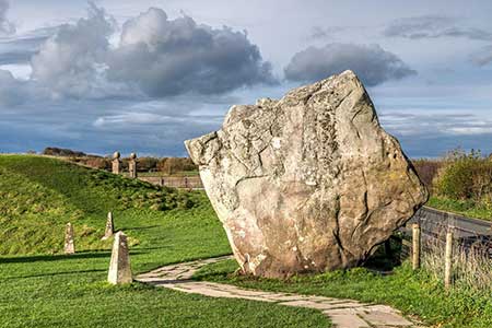
This circular walk from Avebury includes the highlights of some of the finest pre-historic remains in Britain. The route includes man-made Silbury Hill, West Kennett Long Barrow, the Stone Avenue, the Avebury Henge and stone circle, and the concentric earthworks of Windmill Hill.
The walk starts from the main pay and display car park in Avebury (grid ref. SU099696). After parking return to the car park entrance and turn right along the A4361. After 30 metres turn right through a gate with an adjacent fingerpost (signed Silbury Hill). The clear path leads south alongside the infant River Kennett to pass Silbury Hill on your left. Continue ahead to a gate on the A4. Cross carefully to the lay by opposite and turn left. Turn right at the fingerpost (signed West Kennett Long Barrow) and follow the track which soon narrows to a path and turns left. At the next junction (grid ref. SU106682) a path leads right up to the Long Barrow if you wish to explore this feature. If you choose this option return downhill to this junction.
To continue keep ahead at this junction and follow the path along the left-hand edge of the field. This path leads to Gunsite Road. Cross the road to the stile opposite and continue with a hedge on your right. The path sings right and leads into a track. At the first junction, turn left and follow the track to a lane. Turn left, cross the Kennet, and then turn right along a grassy bridleway. After 300 metres, turn left onto a track and continue to the A4. As you approach the A4, the Sanctuary Stone Circle is on your left. Cross the A4 to the track opposite which is part of the Ridgeway National Trail. After 400 metres at a junction, turn left down Overton Hill. Aim for the trees and the adjacent Small Barrows of West Kennett (grid ref. SU115686).
Continue downhill on the permissive path to a further group of Barrows. Continue downhill to a gate, turn right, and walk to the B4003. Cross to the gate opposite and turn right along the field edge. Pass through two gates and walk 800 metres along the Stone Avenue towards Avebury. Exit through a gate on the right behind a large Stone onto the B4003. Cross the road to the gate opposite and follow the clear path through a group of trees to the Avebury Henge and Stone Circle. After exploring the Stone Circle, follow High Street into the village, on the south side of the Red Lion. Continue for 200 metres and turn right into the churchyard. One through the gate, continue half-left to a gate in a wall. Follow clear path ahead, cross the Kennett and bear right at a fork. After 50 metres cross stile on the right (grid ref. SU096669).
The path, part of the White Horse Trail, crosses the field to a footbridge The path crosses several fields with stiles between then to reach a cross track after 600 metres (grid ref. SU097712). Turn left and continue to Windmill Hill with its partially complete earthworks. Cross the hill and drop down to a gate and track on the far side. Turn left and after 150 metres turn left again up a clear track. Walk across open fields for just over a kilometre to a metal kissing gate on your left (grid ref. SU089702). Pass through the gate and follow the grassy bridleway for 150 metres and turn right to join an enclosed track that leads to Bray Street and a road junction. Turn left and when the lane ends continue ahead on a clear path that leads back to the Kennett crossed earlier. Retrace your steps through the churchyard and exit onto Avebury High Street. Turn left and after 100 metres turn right opposite a row of cottages through a gate. The onward path leads back to the car park used at the start of the walk.
Other walks nearby
| Walk 3517 | Avebury & Overton Down | easy/mod | 7.5 miles |
| Walk 2357 | Grey Wethers & Fyfield Down from Hackpen White Horse | easy/mod | 8.5 miles |
| Walk 2339 | Milk Hill the highest point in Wiltshire | easy | 3.0 miles |
| Walk 1807 | The Southern Escarpment of the Marlborough Downs | easy/mod | 6.5 miles |
| Walk 1733 | Wessex Downs & Kennet & Avon Canal from Pewsey | easy/mod | 8.0 miles |
| Walk 3295 | Pewsey Hill and Fyfield Down | easy/mod | 9.0 miles |
| Walk 1928 | Pewsey Downs from Wootton Rivers | easy/mod | 8.0 miles |
| Walk 2255 | Urchfont Hill from Market Lavington | easy/mod | 8.6 miles |
| Walk 2699 | Lacock - a village stroll | easy | 1.0 miles |
| Walk 2410 | Wayland's Smithy, Ashdown House and Ashbury | easy/mod | 7.5 miles |
Recommended Books & eBooks
The Kennet and Avon Canal
 Guidebook to walking along the Kennet & Avon Canal. The 94 mile route from Reading to Bristol is split into 7 stages of fairly easy walking and includes the UNESCO World Heritage Site of Bath and Bristol's Floating Harbour. 20 circular walks are also included, ranging from 4¼ to 9 miles, taking in the best sections of the canal.
More information
Messaging & Social Media
Message Walking Britain and follow the latest news.

Mountain Weather
Stay safe on the mountains with detailed weather forecasts - for iOS devices or for Android devices.