Walk 2385 - printer friendly version
Airton & Bell Busk Circular Walk
Author - Lou Johnson
Length - 6.8 miles / 11.1 km
Ascent - 700 feet / 212 metres
Grade - easy/mod
Start - OS grid reference SD902592
Lat 54.0286970 + Long -2.1510946
Postcode BD23 4AQ (approx. location only)
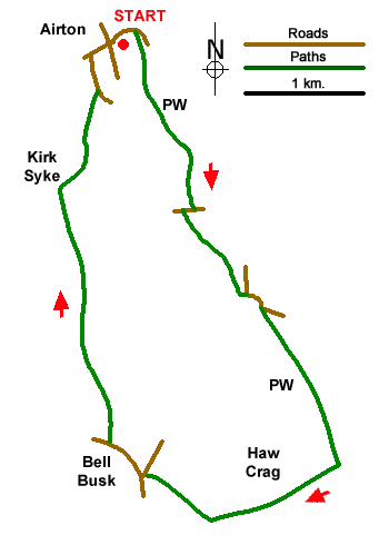
A delightful walk from the attractive village of Airton which lies near the southern boundary of the Yorkshire Dales National Park. The route follows the Pennine Way beside the infant River Aire before turning west across Haw Crag from where you can enjoy an excellent view. Reaching the small community of Bell Busk the walk turns north and follows a bridleway across Higher Colgarth Hill before a gentle descent back to Airton.
On-street parking is available by the village green in Airton (grid ref. SD902592). After parking walk east down Hellifield Road to cross the River Aire over a substantial stone bridge. Once over the river, turn right onto the Pennine Way signed to Gargrave. Follow the clear path, with the river on your right, for just over a kilometre to Newfield Bridge. Turn right across the river and then left onto the continuing Pennine Way. The easy-to-follow path leads south soon reaching a footbridge over the Aire. Cross the bridge and turn left staying on the Pennine Way which runs parallel to a road before trending half-left across Eshton Moor.
The next objective is Har Crag which rises to the right of the Pennine Way. The Pennine way soon reaches the end of a large field. Go through the gate and continue ahead for 350 metres to a feint cross path. Turn right and head up the gentle slope onto Haw Crag. From where the view north into the Yorkshire Dales National Park is excellent. After enjoying the vie join the clear track heading west. Which soon joins a walled track. Reaching a T-junction, turn right and follow the track which soon crosses the Aire and leads to a road (grid ref. SD905564).
Turn left and shortly after right (signed to Bell Busk). After 250 metres the road veers left. Fifty metres beyond this bend, turn right up a gravel track. There is bridleway sign on the adjacent telegraph pole. The track soon crosses a stream to a barn. Follow the track running in front of the barn ignoring the footpath off to the right. Just beyond the barn, the grassy tracks forks. Keep left and return to the grassy track along the left-hand edge of the field. Pass through a gate, pass a stand of trees, and continue ahead at the next gate. Pass another barn and keep ahead soon joining a walled track. Pass the extensive farm buildings at Kirk Syke on your left and walk ahead along a walled lane (Kirk Syke Lane). Continue to a road. Bear left and at the next junction turn right to return to Airton village and the end of the walk.
Messaging & Social Media
Message Walking Britain and follow the latest news.

Mountain Weather
Stay safe on the mountains with detailed weather forecasts - for iOS devices or for Android devices.