Walk 2390 - printer friendly version
High Pike from Fell Side Walk
Author - Lou Johnson
Length - 5.2 miles / 8.5 km
Ascent - 1300 feet / 394 metres
Grade - moderate
Start - OS grid reference NY305375
Lat 54.7276620 + Long -3.0806847
Postcode CA7 8HA (approx. location only)
High Pike (658 metres) lies in the northern fells of the Lake District. The fells at the back o' Skiddaw offer excellent walking with views to the Lake District fells and north across the Solway Firth to the Scottish hills. This route should be avoided in poor visibility as the terrain can be confusing with few obvious landmarks. The ascent route involves a steady climb with only a few steeper sections. Much of area crossed was subject to mining although today nature has reclaimed many of the scars.
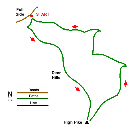
The start is the small parking are at Fell Side (grid ref. NY305375) which lies on the south side of the lane around the northern perimeter of the National Park. After parking walk south up the tarmac track and either cross the stile or pass through the gate into open country. Turn right along a clear track and after 75 metres turn left onto a grassy rising path. After 500 metres you reach a fork with a waymark. Bear left and continue across moorland to reach a cross path after 400 metres (grid ref. NY312368). Bear half right and continue uphill to cross a clear stony cross track. There is evidence of former mining activities on this section of the route with danger areas enclosed by fences.
Continue along the grassy path over Deer Hills and continue to climb reaching a cross path (grid ref. NY318358). Ahead lies the final climb onto High Pike. Pass the remains of an old hut and continue the short way to the summit with its OS trig column and rudimentary stone shelter. The view is excellent with many of the northern Lakeland fells lying to the south. The northern panorama is equally fine with the Solway Firth and Scottish hills in view.
To start the descent head northeast down a grassy path which leads down to a clear track which once served the mines. Bear left and ignoring paths to the right continue for 700 metres to a clear junction of tracks (grid ref. NY328364). Turn sharp left and continue to just before Potts Gill (not named on OS maps) and a complex junction of tracks with adjacent piles of rubble. Turn right and after 250 metres fork left off the main track onto a clear path. Follow this until it nears the main track and turn sharp left at a wall corner. Follow the path beside the wall to the next wall corner and walk ahead to cross Potts Gill. Follow the path heading west to pass Little Fellside Farm on your right. Join the farm's access drive for about 400 metres before veering left off the track along a grassy path. Drop down to a beck and climb up the other side and continue to reach a clear track used at the start of the walk. Turn right through the gate to return to the parking area at Fellside.
Messaging & Social Media
Message Walking Britain and follow the latest news.

Mountain Weather
Stay safe on the mountains with detailed weather forecasts - for iOS devices or for Android devices.