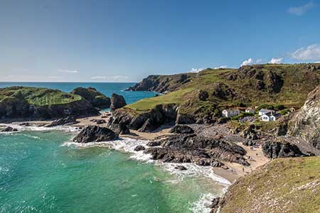
The Lizard Circular from Kynance Cove
Cornwall AONB Walk
Region - Cornwall AONB
County/Area - Cornwall
Author - Lou Johnson
Length - 5.9 miles / 9.6 km Ascent - 900 feet / 273 metres
Time - 3 hours 50 minutes Grade - easy/mod
Maps 

Walk Route Description
Click image to see photo description.
Excellent circular walk from Kynance Cove visiting The Lizard which is the most southerly point of mainland Britain. The route includes all the highlights of the Lizard Peninsula including the coastguards' lookout on Bass Point, the former Lloyds Signal Station (NT), Marconi's bungalow, the lighthouse and some of the finest coastal walking in Cornwall.
The walk starts from the National Trust car park at Kynance Cove (grid ref. SW689132). After parking return to the entrance by the toilets and turn left, pass the metal barrier, and continue along a track. And after 200 metres turn right onto a clear path across the moor. This path soon joins the road used to access the car park. Bear left and where the road bends sharp left, continue ahead between rocks places across the path. After 400 metres you reach a junction by a small stream (grid ref. SW698129). Continue ahead and continue to reach a road in the village of Lizard.
Bear left and follow the road into the main square. Follow the road past the toilets on your right to a junction. Go straight across with an area of grass on your immediate left to reach the main road to the Lizard. Go straight across (signed Church Cove). Continue along Beacon Terrace for 400 metres and fork right to Church Cove. Follow the lane for a further 250 metres to where it bends left. Continue ahead onto a track with adjacent footpath sign. Continue along Green Lane which descends towards the coast soon joining the South West Coast Path which joins by a gate on the left (grid ref. SW715121).
Walk ahead and with the sea on your left continue along the clear coast path. You soon reach Bass Point with Coast Watch Station, and the Lloyds Signal Station. A short distance ahead is the Lizard Wireless Station on your left. Continue along the coast path into Housel Bay with the hotel up on your right. After passing the Lion's Den on your left the next objective the Lizard Lighthouse is on your right, with Lizard Point just ahead. Continue through the car park to the old Lifeboat Station before retracing your steps up the road to reach the coast path on your left signed to Kynance Cove.
From here you have four kilometres of coastal walking back to Kynance Cove. As with many coastal walks do expect plenty of 'ups' and 'downs' as you make progress along the cliffs. The path is never in doubt, and you can relax and enjoy the walk. Nearing Kynance Cove a path forks right up to the car park. However, it is recommended that you stay on the coast path to enjoy the glorious view across the cove. If time permits, I suggest continuing along the coast path at least as far as the café before making your way back to the car park.
Other walks nearby
| Walk 2010 | Housel Bay & Bass Point from the Lizard | easy | 3.5 miles |
| Walk 1032 | Kynance Cove, Cadgwith & The Lizard | moderate | 8.0 miles |
| Walk 1878 | Poldhu Cove to Lizard Point | moderate | 9.5 miles |
| Walk 2001 | Coverack & Lowland Point | easy/mod | 4.2 miles |
| Walk 1778 | Maenporth and Helford Passage Circular | easy/mod | 8.0 miles |
| Walk 2009 | Gillan & Nare Point from Porthallow | easy | 4.7 miles |
| Walk 2007 | Helford Passage & Frenchman's Creek | easy/mod | 7.0 miles |
| Walk 2088 | Rosemullion Head & Mawnan | easy | 4.0 miles |
| Walk 2208 | Marazion - a town stroll | easy | 1.0 miles |
| Walk 3501 | Penzance to Porthcurno via Mousehole and Lamorna | moderate | 11.0 miles |
Recommended Books & eBooks
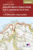
South West Coast Path Map Booklet - St Ives to Plymouth
 Map of part of the southern section of the 630 mile (1014km) South West Coast Path National Trail. Covers the trail from St Ives to Plymouth along the west Cornwall and Devon coastline. This convenient and compact booklet of Ordnance Survey 1:25,000 maps shows the route, providing all of the mapping you need to walk the trail in either direction.
More information
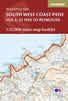
South West Coast Path Map Booklet - Minehead to St Ives
 Map of the northern section of the 630 mile (1014km) South West Coast Path National Trail. Covers the trail from Minehead to St Ives along the north Devon and Cornish coastline. This convenient and compact booklet of Ordnance Survey 1:25,000 maps shows the route, providing all of the mapping you need to walk the trail in either direction.
More information
Messaging & Social Media
Message Walking Britain and follow the latest news.

Mountain Weather
Stay safe on the mountains with detailed weather forecasts - for iOS devices or for Android devices.