East Meon & Wether Down
Countryside Walk + Pub Walk + Downs
Nat Park - South Downs
County/Area - Hampshire
Author - Lou Johnson
Length - 8.0 miles / 13 km Ascent - 800 feet / 242 metres
Time - 4 hours 50 minutes Grade - easy/mod
Maps 

| Ordnance Survey Explorer OL3 | Sheet Map | 1:25k | BUY |
| Anquet OS Explorer OL3 | Digital Map | 1:25k | BUY |
Walk Route Description
Click image to see photo description.
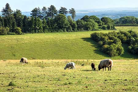
An energetic walk exploring the countryside and downs lying south of East Meon. The route includes the source of the River Meon, a section of the South Downs Way (SDW), Wether Down and Salt Hill. The walk starts from the village hall car park in East Meon (grid ref. SU678222). This car park is signed from the village centre. After parking make your way to the car park entrance and take the signed footpath on the right. Cross the village green to an exit between houses. Bear right and follow Duncombe Road to a T-junction. Turn left and after 120 metres turn left into a parking area (grid ref. SU678219).
At the end of the car park go through a kissing gate to join a path heading south. The path crosses several fields and joins a track running along the left-hand side of a field into a wooded area. Exit the trees and turn left to follow a grassy track across a field with a hedge on your left. At the end, turn left through the hedge and continue with hedge left across another field. Pass through the hedge and turn left to follow the path around the left-hand edge of a field to a road by Lower Farm.
Turn right and then left through kissing gate by adjacent driveway (grid ref. SU684208). Cross the grass, pass through another gate and bear left along drive through South Farm. Continue along the drive across the River Meon near its source. Stay on the driveway which leads into a track. Pass between barns and continue through a gate into a field. The rising path follows the left-hand edge and continues up to the South Downs Way (grid ref. SU693190).
Turn sharp right along the SDW which soon leads to a road. Continue ahead to the road opposite. Where the road forks bear right signed to Droxford. Almost immediately bear left off the road to join the SDW. The path runs roughly parallel to the road, and then leads back to the road. Walk ahead and turn right at the next fingerpost to follow the continuation of the SDW north along a track over Wether Down and Salt Hill. After passing a group of barns the track becomes a path which descends to a road at Coombe Cross. (grid ref. SU667210).
Cross the road and continue along the SDW. The path enters trees, swings right and then left and continues for 450 metres to where the SDW turns left. Continue ahead along Halnaker Lane. for 1.5 kilometres to join a lane which leads to a road (grid ref. SU669232) by Drayton Cottages. Bear left along the road for 200 metres and turn right at the first fingerpost. The path crosses fields to a lane (grid ref. SU667276). Turn right and follow the lane towards East Meon. Reaching a crossroads, go straight across and the car park used at the start of the walk is a short way ahead on the right.
Other walks nearby
| Walk 3260 | Butser Hill Circular | easy/mod | 6.9 miles |
| Walk 2662 | Beacon Hill and Warnford | easy/mod | 6.0 miles |
| Walk 2710 | Old Winchester Hill from Exton | easy/mod | 5.5 miles |
| Walk 2422 | Butser Hill and Wether Down from Buriton | moderate | 12.5 miles |
| Walk 2373 | Hambledon Circular | easy/mod | 6.1 miles |
| Walk 1034 | Beacon and Old Winchester Hills on the South Downs | moderate | 10.5 miles |
| Walk 3324 | Cheriton Mill & Tichborne from Cheriton | easy | 5.7 miles |
| Walk 1976 | Noar Hill from Selborne | easy/mod | 5.0 miles |
| Walk 1964 | Abbotstone from Old Alresford | easy | 5.1 miles |
| Walk 1835 | Treyford & Didling from Hooksway | easy/mod | 6.0 miles |
Recommended Books & eBooks
Walks in the South Downs National Park
 Guidebook with 40 circular walks throughout the South Downs National Park, exploring the beautiful chalk hills between Eastbourne and Winchester. The walks range from under 5 miles to 11 miles, including Beachy Head and the Seven Sisters, Ditchling Beacon and hundreds of prehistoric sites. Accessible all year, but wild flowers best in spring.
More information
Walking Hampshire's Test Way
 Guidebook to walking the 71km (44 mile) Test Way in Hampshire from high on the chalk downs of Inkpen Beacon to the Eling Tide Mill near Southampton Water. Following the beautiful, crystal clear River Test, it passes picturesque villages and fascinating historic sites. Also includes 15 day walks to explore this lovely part of pastoral England.
More information
Messaging & Social Media
Message Walking Britain and follow the latest news.

Mountain Weather
Stay safe on the mountains with detailed weather forecasts - for iOS devices or for Android devices.