Walk 2452 - printer friendly version
Dunsop Head from Slaidburn Walk
Author - Lou Johnson
Length - 7.0 miles / 11.4 km
Ascent - 1000 feet / 303 metres
Grade - easy/mod
Start - OS grid reference SD714524
Lat 53.9668790 + Long -2.4374420
Postcode BB7 3AE (approx. location only)
Starting from the attractive and historic village of Slaidburn, this walk explores the countryside and hills lying north of the village. The route includes woodland, open farmland, and moorland with fine views across the Forest of Bowland National Landscape.
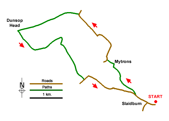
The walk starts from Slaidburn car park located at the east end of the village on the banks of the River Hodder (grid ref. SD7145240. Exit the car park and turn right and walk up into the village. Reaching the junction by the Hark to Bounty Inn, continue ahead to reach a health centre on the right-hand side. Just past the building turn right over a stile into woodland. The path runs above Croasdale Beck on your right. Cross a ladder stile over a wall and continue through two gates at the edge of the wood. Entering a field keep to the left-hand edge. Cross a ladder stile and continue to a gate and a small stone footbridge. Cross the next field to a gap in the far corner. Continue beside a wall on your right and turn sharp right along an enclosed green lane to reach Myttons (grid ref. SD702535).
Turn left along a farm drive to reach a lane. Turn right and follow the lane which rises gently for 1.6 kilometres to reach a gate (grid ref. SD6925148). Pass through the gate and continue up a concrete track for 100 metres and turn sharp left at fingerpost to join a bridleway. After a section beside a wall, the rising track heads southwest across the flank of Dunsop Fell with a valley down to your left. As you make progress the track fades to a grassy path and soon levels off. Reaching a wall at Dunsop Head, turn left and follow the grassy path south with a wall on your left.
After 300 metres the path veers away from the wall and contours round the east side of Wisket Hill to reach a path junction (grid ref. SD679539). Fork left and follow an improving path east with the valley on your left. The onward route heads down the ridge towards a wall at Burn End. The path turns sharp right and continues down to a gate in the wall on your left. The path continues downhill to pass Burnside Cottage on your right. Once past the cottage the route follows an access drive past pools to reach a T-junction (grid ref. SD694530). Turn left and follow the lane back to Slaidburn, an easy walk of two kilometres.
Messaging & Social Media
Message Walking Britain and follow the latest news.

Mountain Weather
Stay safe on the mountains with detailed weather forecasts - for iOS devices or for Android devices.