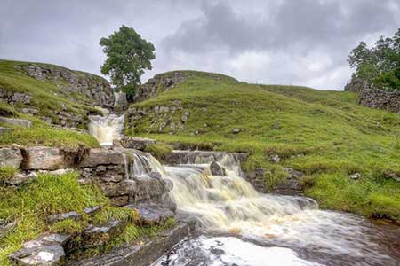
Cow Close Gill Waterfalls from Buckden
Pub Walk + Waterfalls + Historic Church
Nat Park - Yorkshire Dales - Upper Wharfedale
County/Area - North Yorkshire
Author - Lou Johnson
Length - 4.6 miles / 7.5 km Ascent - 600 feet / 182 metres
Time - 2 hours 50 minutes Grade - easy/mod
Maps 

| Ordnance Survey Explorer OL30 | Sheet Map | 1:25k | BUY |
| Anquet OS Explorer OL30 | Digital Map | 1:25k | BUY |
Walk Route Description
Click image to see photo description.
Starting from Buckden in Wharfedale this walk provides the chance to see and explore Cow Close Gill Waterfall. The route follows good paths through glorious scenery. Along the way you can also visit St Michael and All Angels church at Hubberholme before following the Dales Way back to the start. There are three pubs on the walk - the Buck Inn at Buckden, the White Lion at Cray and the George Inn at Hubberholme.
The walk starts from the Yorkshire Dales National Park car park at Buckden (grid ref. SD942773). After parking walk to the north end of the car park and join the Pennine Journey long distance trail. The clear path climbs steadily through the scattered trees of Rakes Wood onto open pastures with an excellent view to the left across Upper Wharfedale. Ignore paths to the right and left and continue into a side valley. The path soon becomes level with the view ahead including Cray High Bridge.
As you approach the road you cross Cow Close Gill. To your right you can see a dramatic series of cascades at the gill tumbles down the fellside. If time permits turn right off the main path and walk up beside the gill to explore the waterfalls. The best time to see the falls is after a period of heavy rain as they are extremely dramatic when in spate. After exploring the falls, return to the main path and continue up to the road (grid ref. SD944797).
Turn left and head downhill to Cray. Leave the right and follow a track running behind the White Lion (signed to Yockenthwaite and Stubbing Bridge). Reaching a fork in the track, keep right and continue past the buildings and turn left at the fingerpost and descend across open country down to the River Wharfe. The path continues beside the river on your left to reach Stubbing Bridge. Turn right along the lane and continue for 800 metres to Hubberholme with its lovely church and the George Inn (grid ref. SD926782). Turn left in front of the George Inn and continue for 600 metres to reach a gate on the left with an adjacent fingerpost. Pass through the gate to follow the broad path (part of the Dales Way) which soon reaches the River Wharfe. Continue beside the river to reach Dubb's Lane. Turn left and return to Buckden village.
Other walks nearby
| Walk 1926 | Pen-y-ghent & Littondale | hard | 16.0 miles |
| Walk 1250 | Great Whernside | moderate | 8.0 miles |
| Walk 1277 | Starbotton & Kettlewell circular | easy/mod | 5.0 miles |
| Walk 1294 | Arncliffe & Kettlewell Circular | moderate | 7.0 miles |
| Walk 1632 | Arncliffe & Starbotton from Kettlewell | moderate | 7.0 miles |
| Walk 1278 | Cosh & Foxup | easy/mod | 6.5 miles |
| Walk 2332 | Mastilles Lane & Bordley from Kilnsey | easy/mod | 6.8 miles |
| Walk 3392 | Darnbrook Fell & Fountains Fell | moderate | 6.4 miles |
| Walk 2265 | Semer Water, Stalling Busk & Marsett | easy | 4.0 miles |
| Walk 3301 | Conistone to Grassington via the Dib | easy | 5.0 miles |
Recommended Books & eBooks
Walking in the Yorkshire Dales: South and West
 Part of a two-book set, this guidebook describes 44 walks in the southern and western Yorkshire Dales, including the famous 23 mile Three Peaks circuit over Pen-y-Ghent, Whernside and Ingleborough. The other, mostly circular routes of 3½ to 13 miles cover the scenic region between Sedbergh, Kirkby Lonsdale, Settle, Skipton and Grassington.
More information
Walking in the Yorkshire Dales: North and East
 This guidebook contains 43 circular day walks in the north and east Yorkshire Dales. It explores the dales, hills and moors between Kirkby Stephen and Pateley Bridge. Walking ranges from gentle 3 mile strolls to more strenuous day-long rambles across the Howgills, Wensleydale, Swaledale, Nidderdale, Mallerstang and Coverdale.
More information
Messaging & Social Media
Message Walking Britain and follow the latest news.

Mountain Weather
Stay safe on the mountains with detailed weather forecasts - for iOS devices or for Android devices.