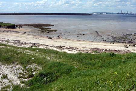
Egypt Bay & St Mary's Bay from High Halstow
Kent Walk
County/Area - Kent
Author - Lou Johnson
Length - 7.5 miles / 12.2 km Ascent - 150 feet / 45 metres
Time - 3 hours 50 minutes Grade - easy
Maps 

| Ordnance Survey Explorer 163 | Sheet Map | 1:25k | BUY |
| Anquet OS Explorer 163 | Digital Map | 1:25k | BUY |
Walk Route Description
Click image to see photo description.
The Thames estuary is often seen as a desolate area despite being close to many large centres of population. This may be true but it is also home to a variety of sea birds who thrive on the mud banks. It is also an area that offers some peace and quiet and this walk does offer solitude and wide open skies.
The start is the parking are at Woodside on the north-western edge of the village of High Halstow (grid ref. TQ781757). High Halstow is just to the north of the A228 which leads to the Isle of Grain. From the car park return along Woodside and turn left into Northwood Avenue. After just under 200 metres take the footpath on your left between houses to reach a field. Continue half right to the edge of the woodland (grid ref. TQ782760). Turn right onto the Saxon Shore Way and after 400 metres and a yellow waymark turn left. The path initially runs along the side of a field before entering woodland and continues to Decoy Hill Road (grid ref. TQ786765).
Turn left along the road and go right in front of Decoy Farm and continue on the lane until you reach Swigshole (grid ref. TQ788775) where the surfaced lane ends. Continue ahead on a clear track (manor Way) in a northerly direction for approximately 1.5 km to reach Egypt Bay (grid ref. TQ777790) and the southern shore of the Thames Estuary. Turn right (with the estuary on your left) and follow the shoreline path along the sea wall to St Mary's Bay and a clear path junction (grid ref. TQ795787).
Turn right here and continue south to St Mary Hoo, a pretty hamlet with its own church. Bear left around Ross Farm and follow the road as it bends to the right. The road soon bends left. Here take the track on your right and continue in a westerly direction to Newlands farm (grid ref. TQ796763). From here take the track continuing in a westerly direction (ignoring the tarmac lane heading south). This track continues along the field edges towards Decoy Hill Road (grid ref. TQ789762). (The final section of this path is Saxon Shore Way). Bear right along the road and take the first signed path on your left just after the lane bends right. This is a continuation of the Saxon Shore Way and this is followed to the edge of the woods first encountered at the beginning of the walk. Bear left across the field to the enclosed path leading onto Northwood Avenue. Turn right and retrace your steps back to the parking area.
Other walks nearby
| Walk 2104 | Blue Bell Hill to Kit's Coty House | easy/mod | 8.8 miles |
| Walk 2210 | Holly Hill & Coldrum Long Barrow | easy/mod | 5.0 miles |
| Walk 3326 | Ringlestone & High Wood from Harrietsham | easy/mod | 8.0 miles |
| Walk 1637 | Rivers Swale & Oare | easy | 5.0 miles |
| Walk 3645 | Burnham-on-Crouch to Fambridge | easy/mod | 9.5 miles |
| Walk 2156 | Lullingstone Castle Circular | easy | 4.0 miles |
| Walk 2333 | Lullingstone & Preston Hill near Shoreham (Kent) | easy/mod | 6.6 miles |
| Walk 1510 | Otford, Romney Street & Woodlands | moderate | 14.5 miles |
| Walk 1610 | Otford, Romney Street & Kemsing | mod/hard | 16.8 miles |
| Walk 3598 | Knockholt via Pratt's Bottom, Mace Farm and The Washneys | easy/mod | 7.3 miles |
Recommended Books & eBooks
Walking in Kent
 A guidebook describing 40 walks in the county of Kent. Covering west Kent and The Weald and north and east Kent, including the Kent Downs and the Greensand Hills. Walks of 5 to 9 miles explore rivers and coastline, beautiful countryside and historic villages. With outlines of 11 longer walks ranging from 15 to 163 miles.
More information
Messaging & Social Media
Message Walking Britain and follow the latest news.

Mountain Weather
Stay safe on the mountains with detailed weather forecasts - for iOS devices or for Android devices.