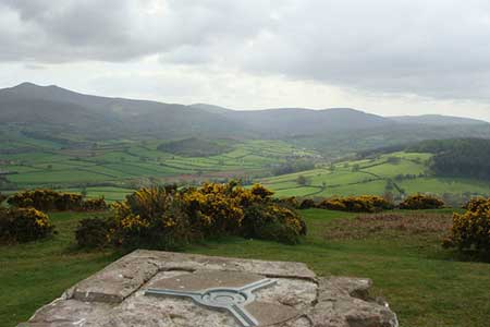
Pen-y-crug, Sarnau and Battle from Brecon
Brecon Beacons/Bannau Brycheiniog Walk
Nat Park - Brecon Beacons - Brecon Beacons Central
County/Area - Powys
Author - Lou Johnson
Length - 10.0 miles / 16.3 km Ascent - 1250 feet / 379 metres
Time - 6 hours 20 minutes Grade - moderate
Maps 

| Ordnance Survey Explorer OL12 | Sheet Map | 1:25k | BUY |
| Anquet OS Explorer OL12 | Digital Map | 1:25k | BUY |
| Ordnance Survey Explorer 188 | Sheet Map | 1:25k | BUY |
| Anquet OS Explorer 188 | Digital Map | 1:25k | BUY |
Walk Route Description
Click image to see photo description.
The start for this walk is Brecon on the banks of the River Usk. There are several car parks in the centre but the long-stay car parks by the Watergate Bridge (grid ref. SO042286) and on the promenade (grid ref. SO038289) are the most convenient for this walk. After parking walk to the cathedral and follow Pendre, the B4520 north towards the edge of the built-up area.
Approximately 600 metres along the B4520 from the Cathedral (grid ref. SO042295), turn left onto a surfaced lane heading roughly northwest. Reaching a junction after 600 metres (grid ref. SO038301) turns left along what is a now a narrower track past Crug Vila and into open access country surrounding Pen-y-crug fort. An obvious path leads through the earthworks to reach the OS trig point from where there are excellent views especially south to the Usk Valley.
To continue head north using one of many paths to enter a green lane (grid ref. SO028309). Follow this to a road. Cross the road and take the signed footpath opposite. This crosses two fields before turning right and skirting the southern boundary of woodland (Coed Gwenffrwd) to reach another lane (grid ref. SO031314). Turn left along this lane with woodland to your left. The lane enters more woodland (Glanhon Ddu) and after just under a kilometre since joining this lane at Llanerchwen, take the signed footpath on the right (grid ref. SO02431). The path is marked with green arrows and leads to a lane south of Sarnau (grid ref. SO028324).
Turn left along the lane. Take the first narrow lane on your left and walk past Henllys on your left. Pass through another section of woodland (both sides of the road). Ignore turnings left and right and continue ahead on what has become a track to reach a lane (grid ref. SO009332). Walk down this quiet lane south, bearing left when you reach (grid ref. SO009318) a wider lane. This leads you into the village of Battle.
Just before the chapel in Battle turn right down a bridleway (grid ref. SO008310). Follow this bridleway initially west before swinging south. The bridleway crosses a narrow lane (grid ref. SO004306) and continues southwards to reach another lane at Pont-ar-Yscir (grid ref. SO003302). Here, take the footpath opposite which crosses several fields before making a beeline to Y Gaer farm (grid ref. SO004298). This is the site of a Roman fort. Turn left here to join a grassy bridleway heading east for about 3 kilometres to join Fenni-fach Road. Turn left towards Brecon passing the car park suggested on the Promenade (grid ref. SO038289). Bear right onto the riverside path along the River Usk into the centre of Brecon to reach the other recommended car park at Watergate Bridge.
Other walks nearby
| Walk 3209 | Llanfrynach and Pencelli circular | easy/mod | 5.6 miles |
| Walk 2400 | Pen y Fan from Cwmgwdi near Brecon | moderate | 5.0 miles |
| Walk 1903 | Pen y Fan & Corn Du from Cwmgwdi | moderate | 7.5 miles |
| Walk 2074 | Highest Peaks of the Brecon Beacons | mod/hard | 11.0 miles |
| Walk 3546 | Pen y Bryn from Pencelli | moderate | 5.0 miles |
| Walk 3536 | Pen y Bryn & Carn Pica from Pencelli | mod/hard | 11.3 miles |
| Walk 2648 | The Black Mountain, Brecon Beacons | moderate | 8.0 miles |
| Walk 2641 | Fan Fawr & Fan Frynych, Fforest Fawr | moderate | 6.5 miles |
| Walk 2349 | Pen Y Fan & Corn Du from near Storey Arms | moderate | 4.6 miles |
| Walk 3616 | Fan Fawr from Storey Arms | moderate | 6.0 miles |
Recommended Books & eBooks
Walking on the Brecon Beacons
 45 circular day walks are described in this guidebook to the Brecon Beacons National Park. From west to east, Mynydd Du, Fforest Fawr, the Brecon Beacons and the Black Mountains these mountain and valley routes offer many options, highlighting the natural features. The walks described explore dramatic waterfalls, wooded gorges and upland valleys.
More information
The Cambrian Way
 Guidebook to the Cambrian Way, a challenging three-week mountain trek through Wales from Cardiff to Conwy. The 470km un-waymarked route is presented from south to north. Often sticking to long, beautiful ridgelines, it crosses wild and rugged terrain and visits many of Wales's highest mountains, including Snowdon.
More information
Messaging & Social Media
Message Walking Britain and follow the latest news.

Mountain Weather
Stay safe on the mountains with detailed weather forecasts - for iOS devices or for Android devices.