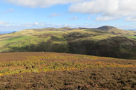
Carnethy Hill, Black Hill & Caerketton Hill from Flotterstone
Midlothian Walk
County/Area - Midlothian
Author - Lou Johnson
Length - 12.5 miles / 20.3 km Ascent - 3500 feet / 1061 metres
Time - 9 hours 50 minutes Grade - mod/hard
Maps 

| Ordnance Survey Explorer 344 | Sheet Map | 1:25k | BUY |
| Anquet OS Explorer 344 | Digital Map | 1:25k | BUY |
Walk Route Description
Click image to see photo description.
This walk from Flotterstone explores the hills and ridges of the Pentland Hills. The route includes the ridge to Carnethy Hill from where an ascent of Black Hill completes the first half of the circuit. The walk continues over Harbour Hill and Capelaw Hill before continuing along the ridge from Allermuir Hill to Caerketton Crags. The route continues at a lower level back to the start.
The start is the car park at the Flotterstone Visitor Centre (grid ref. NT233631) which lies on the north side of the A702. After parking follow the road leading to Glencorse Reservoir. After 400 metres, turn left onto the path signed to Scald Law (grid ref. NT229631). After a further 100 metres cross the burn, climb the embankment, and cross a stile. The path then climbs steeply passing between trees to gain the shoulder of Turnhouse Hill. Continue over the summit of Turnhouse Hill (506 m.) and descend to a bealach.
Another steep climb takes you onto Carnethy Hill (573 m.). Descend westwards down to a bealach with Scald Law ahead. Cross the fence at the bealach and turn right (northwest) down the slope to Green Cleuch near the Howe (grid ref. NT190620). Cross the burn and turn right along a private road with Logan lee Reservoir on your right. After about 400 metres locate a grassy track on your left just before a bridge. Continue up the track which follows a looping route to the summit of Black Hill (501 m.).
Continue northeast descending to a section of wet ground in a valley. Cross the burn and veer right to join a fence on the north western flank of Bell's Hill. After a descent into Maiden's Cleugh climb beside the fence to reach the summit of Harbour Hill (421 m.). Descend into Phantom's Cleugh bearing right to join a grassy path to ascend Capelaw Hill (454 m.). Descend east-north-east to cross a stile (grid ref. NT223660). Cross the track and head uphill to the summit of Allermuir Hill (493 m.) with its OS trig column.
Leave the summit heading northeast following the fence and continue across the rocky twin summits of Caerketton Hill (478 m.). Continue northeast down a steep path to cross a stile (grid ref. NT245662). Turn right (signed to Boghall) and continue down to the edge of a plantation. Cross a stile and follow the edge of the plantation (on your left). Continue over another stile to reach radio masts above Boghall. Continue west down to a track. Turn right on the track heading into a valley.
After passing through a gate, bear right off the track to descend into wet ground. Cross the burn and a stile to reach a grassy track with the plantation on your left. Contour around the base of Woodhouselee Hill with trees on your left. Descend into a valley and continue south keeping the trees on your left. Continue across the south-east ridge of Castlelaw Hill to join a track near the firing range. Continue through the parking area and turn right to pass Castlewlaw Farm on your right. Continue along the track for 180 metres and turn left on path (signed to Flotterstone). This path leads down to a private road. Turn left and continue back to the start.
Other walks nearby
| Walk 1936 | Scald Law and Pentland Hills Ridge from near Penicuik | mod/hard | 7.4 miles |
| Walk 3291 | West Kip, East Kip & Scald Law | moderate | 9.7 miles |
| Walk 1700 | Edinburgh - Royal Mile, Arthur's Seat & Princes Street | easy | 5.5 miles |
| Walk 1803 | Edinburgh - Salisbury Crags and the Royal Mile | easy | 4.0 miles |
| Walk 2061 | Edinburgh - Calton Hill and the city centre | easy | 3.0 miles |
| Walk 2241 | Gladhouse Reservoir | easy | 4.0 miles |
| Walk 3294 | Trahenna Hill from Broughton | moderate | 7.1 miles |
| Walk 1979 | Culross Heritage | easy | 1.5 miles |
| Walk 3293 | Three Brethren & Brown Knowe from Yarrowford | moderate | 8.3 miles |
| Walk 1557 | The Falkirk Wheel and the Kelpies | easy/mod | 8.0 miles |
Recommended Books & eBooks
No suggestions for this area.Messaging & Social Media
Message Walking Britain and follow the latest news.

Mountain Weather
Stay safe on the mountains with detailed weather forecasts - for iOS devices or for Android devices.